


Latest News
03.07.2023 July 2023: Detecting eddies around Antarctica
Sea level anomalies gridded datasets encompassing seasonnally-ice covered regions have been computed and released for Arctic and Antarctic. From those, Eddy Kinetic Energy (EKE) and mesoscale eddies detection can be processed.
30.06.2023 Swot campaign in the Western Pacific
")
The Cruise LGD2308 left Taiwan onboard the ship Legend to measure sea surface heights and detecting oceanic eddies using GNSS for Swot validation (June 23 -July 3, 2023)[more]
30.06.2023 SWOT L2_NALT_O/IGDR and L2_RAD_O/IGDR Release
The Surface Water and Ocean Topography (SWOT) project is pleased to announce the public release of Level 2 science data products from the onboard nadir altimeter (NALT) and advanced microwave radiometer (AMR). [more]
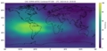
22.06.2023 El Niño’s back in 2023

Altimetry sea level anomalies have been showing an elevation all along the Equator in the Pacific for the past four months.[more]
22.06.2023 Monitoring of the Kakhovka reservoir/river by altimetry

The Hydroweb database – hydroweb.theia-land.fr – is monitoring changes in water levels over time on large lakes, reservoirs and rivers, from altimetry measurements. Hydroweb was not originally designed to monitor...[more]
16.06.2023 Fifth Space for Hydrology Workshop (Hydrospace 2023)
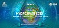
ESA, Cnes and Gewex are organising a sequel joint event to Hydrospace 2021 and EO4Water 2020: The 5th Space for Water Cycle and Hydrology Workshop, Hydrospace 2023.[more]
07.06.2023 June 2023: Doris validates GNSS-based ionospheric models
Doris RT data from Jason-3 can be used to evaluate the quality of ionosphere models from GNSS data
News
- Search.
- Front-page news.
 Image of the month .
- Press review.
- Operational news and status .
- News from CTOH .
- Events calendar.