


News
Typhoon Neoguri seen by altimeters
Typhoon Neoguri seen by altimeters : humps of sea level anomalies and high waves.
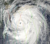
Photos collage with HY-2A tracks and true photo from the space (Nasa, A.Gerst).
The tropical storm Neoguri started on late of June and increased through the Western Pacific up to the Category 4 on the Saffir-Simpson scale with wind speed up to 250 km/h. Heavy rains caused some landslides over Japan.
By directly measuring the sea surface height, altimetry identifies humps at places where the upper layer of the ocean has dilated due to higher temperatures. Altimetry is therefore capable of finding these warm eddy areas whose hurricane heat potential is proportional to the underlying volume of warm water, i.e. the higher the temperature of the water column (and not only the temperature of the ocean's surface), the more likely it is that the cyclone will gain strength when it passes.
Tropical cyclones are also characterised by very high waves and strong winds, that can be measured by altimeters (provided that the satellites fly close enough to the area affected by the cyclone) and assimilated in real-time in some forecasting models.
<media 14260 1100x1800 - "IMAGE, 201407 neoguri msla track nrt global allsat msla 20140707, 201407_neoguri_msla_track_nrt_global_allsat_msla_20140707.png, 540 KB">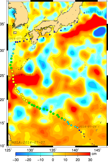 </media> </media> | <media 14262 600x900 - "IMAGE, 201407 neoguri HY2A SWH, 201407_neoguri_HY2A_SWH.png, 138 KB">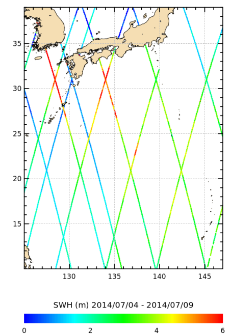 </media> </media> |
Ssalto/Duacs maps of Seal Level Anomalies (in cm) made from 4 altimetry mission (Jason-2, Cryosat-2, Saral and HY-2A), on 2014/07/07 when the typhoon is max. The typhoon path is shown by colored circles (the intensity scale is purple for a tropical depression, blue for cat. 1, green for cat. 2, yellow for cat. 3, orange for cat.4 and red for category 5. The dates near the path indicates the date when the hurricane passed. Credits Cnes/CLS Ssalto/Duacs. | Maps of significant wave height (in m) measured along-track by HY-2A over the ocean. Only the ground tracks between the 2014/07/04 and the 2014/07/09 are represented. Credits Cnes/CLS Ssalto/Duacs. |
Further information:
- Applications: <link internal-link>Hurricanes
- Altimetry applications in videos: <link internal-link>Monitoring hurricanes
- Nasa Earth Observatory: <link http: earthobservatory.nasa.gov naturalhazards _blank external-link-new-window>Typhoon Neoguri


