

CNES/CLS/LOcean/CTOH/LEGOS
"Filaments: altimetry on a thread" poster
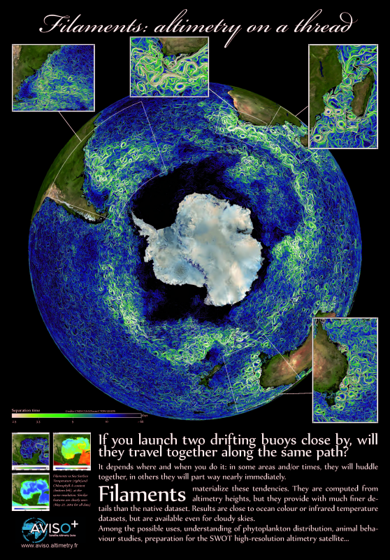
If you launch two drifting buoys close by, will they travel together along the same path, or not? In fact, it depends where and when you do it. In some areas, they will huddle together, in others they will part way nearly immediately. Filaments materialize these tendencies (colour scale gives the time two adjacent water particles will take before breaking apart). They are computed from altimetry heights using a maximal period of 200 days. Most importantly, they provide with much finer details than the native dataset (from 1/4° to 1/25°), close to what is available from ocean colour or infrared temperature, but even for cloudy skies. Among the possible uses, understanding of phytoplankton distribution, animal behaviour studies, preparing for the SWOT high-resolution altimetry satellite...
Downloads
| File | Type | Size | Lang | Resolution | Creation date | Represented date |
|---|---|---|---|---|---|---|
| FSLE_poster.jpg | Image | 2.63Mb | en | 2481x3555 | 2015-03-31 | 2014-05-27 |
| FSLE_postersm.pdf | Electronic document | 2.17Mb | en | 2015-03-31 | 2014-05-27 | |
| FSLE_poster.pdf | Electronic document | 37.34Mb | en | 2015-03-31 | 2014-05-27 |
- Geographic area : All oceans
- Instrument : Altimeter
- Parameter : Filaments
- Topic : Mesoscale Ocean circulation (eddies)
- Satellite : Multimission