


EU Copernicus Marine Service, CLS, Cnes, Legos
Mean Sea Level from altimetry - 1993-2021
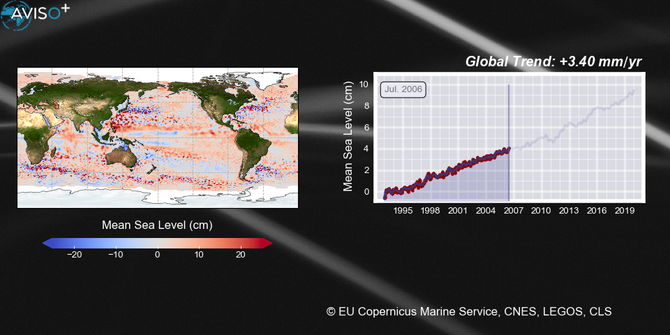
The global mean level of the oceans is one of the most important indicators of climate change. It incorporates the reactions from several different components of the climate system. Precise monitoring of changes in the mean level of the oceans, particularly through the use of altimetry satellites, is vitally important, for understanding not just the climate but also the socioeconomic consequences of any rise in sea level.
Map left show the daily maps of sea level variations, curve right the mean sea level over the whole oceans month by month since 1993.
Update May 2022, data up to Jul. 2021.
Further information, updates and download on www.aviso.altimetry.fr/msl
Downloads
| File | Type | Size | Lang | Resolution | Creation date | Represented date |
|---|---|---|---|---|---|---|
| dt_global_allsat_msla_h_filtered_20060705_20171201_map_timeserie.png | Image | 444.25kb | 960x480 | 2020-03-20 | -0001-11-30 | |
| video_gmsl_duo_highresAviso.mp4 | Video | 33.58Mb | 2022-05-16 |
- Geographic area : All oceans
- Instrument : Altimeter
- Parameter : Sea level anomalies
- Topic : Climate, Mean Sea Level
- Satellite : Multimission