


Cnes/Mira Production
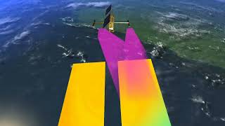
Swot: Improving spatial resolution (video)
Altimetry satellites have been surveying the world’s oceans since the early 1970s, using a range-measurement technique that was employed for the first time by U.S. satellites, notably Seasat launched in 1978.
Since then, each new generation of satellites—Topex/Poseidon and then Jason—has increased spatial resolution by continuously improving the quality of instruments, data processing and geophysical corrections needed to observe the signature of the ocean circulation.
While these advances have significantly improved spatial resolution along the satellite track, currently 30 to 50 km, the main challenge has been to obtain a two-dimensional picture of the ocean. Even by combining all altimetry measurements available today, we can only map the ocean at no more than an average resolution of about 150 km, which restricts our ability to observe many ocean phenomena.
Swot, set to launch in 2021, will usher in a new generation of satellites and a new remote-sensing technique. Where Jason acquires a mean measurement from the nadir every 7 km, Swot’s radar interferometer will offer a two-dimensional view covering a swath of 120 km. As a result, the pixel size will be greatly reduced—to a few hundred metres or so. When observing the ocean circulation, after factoring in measurement noise, the mean resolution will be 10 to 15 km—a tenfold improvement over the Jason satellites.
That kind of performance will allow scientists to see things they couldn’t see before, such as small ocean eddies, mesoscale phenomena of the order of 20 to 120 km, and coastal marine currents. They also expect to be able to quantify the surface signal of internal waves, opening the door to a deeper understanding of the global ocean circulation.
Downloads
| File | Type | Size | Lang | Resolution | Creation date | Represented date |
|---|---|---|---|---|---|---|
| improvingspatialres.jpg | Image | 6.53kb | 320x180 | 2019-10-01 | ||
| amelioration_resolution_fr_sd.mp4 | Video | 22.05Mb | fr | 2019-10-01 | ||
| amelioration_resolution_fr.pdf | Electronic document | 6.1Mb | fr | 2019-10-01 | ||
| improving_spatial_resolution_SD.mp4 | Video | 22.02Mb | en | 2019-10-01 | ||
| improving_spatial_resolution.pdf | Electronic document | 6.09Mb | en | 2019-10-01 |