


Cnes/Mira Production, 2021
Lake and inland sea ice video
updated 2021
Satellite altimetry also enables ice to be monitored in high-latitude inland seas and large lakes. Satellites, notably those with radar altimeters, are well suited to developing this application. Broadly speaking, as with the rivers of Siberia, global warming is causing ice to melt earlier in spring and its extent appears to be declining. This is an important
factor for shipping, economies and tourism in affected regions.
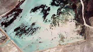
Greater Aral Sea
The Aral Sea is a somewhat special case.The impact of humans is the main driver.The
level and surface area of the Greater Aral have declined significantly, making it more
saline. Its freezing point has dropped from –2° to –8°C and the ice extent has greatly decreased.
Conversely, the level and area of the Lesser Aral have increased thanks to the dam diverting water from the Syr Daria, its salinity has stabilized and winter ice coverage has recovered to somewhere near the levels of past decades. Researchers are also working on other regions like the Caspian Sea, Lakes Baikal, Hovsgol, Ladoga and Onega. In all of these regions, satellite altimetry data are helping to better understand and predict the impacts of humans and climate change.
Downloads
| File | Type | Size | Lang | Resolution | Creation date | Represented date |
|---|---|---|---|---|---|---|
| 08_inland_sea_ice.jpg | Image | 13.99kb | 320x180 | 2021-10-01 | ||
| 08_inland_sea_ice.mp4 | Video | 15.85Mb | en | 2021-10-01 | ||
| 08_lake_island_sea_ice.pdf | Electronic document | 2.79Mb | en | 2021-10-01 | ||
| 08_glaces_interieures.mp4 | Video | 16.02Mb | fr | 2021-10-01 | ||
| 08_mers_interieures.pdf | Electronic document | 2.79Mb | fr | 2021-10-01 |
- Geographic area : Asia, Europe, North America
- Instrument : Altimeter
- Parameter : Ice concentration, Surface height
- Topic : Sea Ice
- Satellite : Multimission