

Cnes/Mira Production, 2021
Helping in hurricane forecasting video
updated 2021
In April 2016, Cyclone Fantala tore into the Farquhar group of islands, with winds of over 350 km/h. The monster storm hit outside the cyclone season and its track remains unexplained to this day, since it doubled back on itself and battered the archipelago three times—something never seen before. And what of Hurricane Patricia in Mexico and Cyclone Pam in Vanuatu during the 2015-2016 season, for which storm specialists had to add a sixth category to the hurricane scale? With rising water temperatures fuelled by global warming, we have every reason to wonder what the future has in store.
In this context, satellites are going to be increasingly vital to observe and model hurricanes. While weather satellites are able to watch them develop in near-real time, from their perch above the clouds they can’t really see what’s happening at sea level. As well as measuring radiation emitted from Earth in L-band, the SMOS satellite has also shown its ability to measure surface winds. This is a key parameter to better forecast
hurricane intensification, currently the weak point of operational centres’ models.
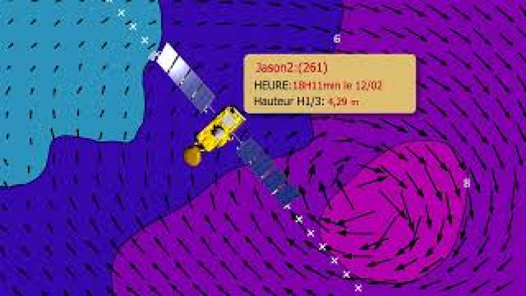
Meanwhile, altimetry satellites are helping to more accurately forecast hurricane swell to keep seafarers and coastal populations safe, even hundreds of kilometres from the storm. Waves, sometimes higher than 10 metres, are measured by the altimeter as the
satellite flies overhead and readings are assimilated in near-real time into predictive
models like those used by Meteo France.
But satellite altimetry doesn’t just measure wave heights; it also highlights sea level anomalies, revealing zones of warm water where storms gather force. For example, data from Jason show that the track of Cyclone Fantala was at the edge of a zone where sea level was exceptionally high in April 2016 compared to previous years, as a result of El Ni. Such complex phenomena should be interpreted with caution and the track of a hurricane is determined by atmospheric currents, but it’s likely this zone was a store of energy available to sustain and amplify Cyclone Fantala.
https://www.aviso.altimetry.fr/en/applications/atmosphere-wind-and-waves/hurricanes.html
https://youtu.be/zD3ogZDChXk
Downloads
| File | Type | Size | Lang | Resolution | Creation date | Represented date |
|---|---|---|---|---|---|---|
| 15_hurricanes.jpg | Image | 11.53kb | 320x180 | 2021-10-01 | ||
| 15_hurricanes.mp4 | Video | 24.92Mb | en | 2021-10-01 | ||
| 15_helping_hurricane_forecasting.pdf | Electronic document | 2.49Mb | en | 2021-10-01 | ||
| 15_cyclones.mp4 | Video | 24.81Mb | fr | 2021-10-01 | ||
| 15_cyclones.pdf | Electronic document | 2.48Mb | fr | 2021-10-01 |
- Geographic area : Atlantic Ocean, Indian Ocean, Pacific Ocean
- Instrument : Altimeter
- Parameter : Wave height, Wind speed
- Topic : Wind and waves
- Satellite : Multimission