

Aviso
30 years of El Niño by altimetry poster
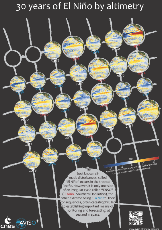
Thirty full years of homogeneous, cross-calibrated, altimetry data are now available, from Jan 1993 to Dec. 2022 (even if Topex/Poseidon provided with data a bit ealier, in October 1992). Far from being an idle accumulation, this amount of data enables to monitor the whole ocean and its diverse variabilities and phenomena, and to help in forecasting them and their more harmtful impacts. Among those phenomena, one of the best-known and most threatening is ENSO (El Niño Southern Oscillation), El Niño and La Niña and their sometimes far-reaching effects all around the oceans and continents. Others have been monitored during those thirty years, too -- eddies such as the Loop Current eddies, or recurring ones like the Ierapetra gyre, current location shifts (Gulf Stream or Kuroshio in particular), of course the mean sea level rise, etc.
The continuation of the time series initiated by Topex/Poseidon with Sentinel-6 Michael Freilich and Sentinel-6B (to be launched in 2025) will provide longer monitoring, and better understanding of those, and possibly other phenomena. The next missions are already being considered and designed now, to take over on time and keep the continuity on.
see also: https://www.aviso.altimetry.fr/enso
Downloads
| File | Type | Size | Lang | Resolution | Creation date | Represented date |
|---|---|---|---|---|---|---|
| poster_nino30ans_calendrier.png | Image | 14.08Mb | en | 4961x7016 | 2023-01-15 | |
| poster_nino30ans_calendrier.pdf | Electronic document | 8.66Mb | en | 2023-01-15 |
- Geographic area : Pacific Ocean
- Instrument : Altimeter
- Parameter : Sea level anomalies
- Topic : Climate, El Niño
- Satellite : Jason-1, Jason-2, Jason-3, Sentinel-6 (Jason-CS), Multimission, Topex/Poseidon