


CNRS/CEBC/CLS
Penguins at the edge of the eddies
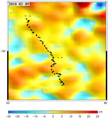
Path of two King penguins from the Argonautica campaign 2009-2010 superimposed on sea surface height anomalies (in cm); They both started from the Possession island in the Crozet Archipelago. One is named "King" by the students, the second is "Garfield". They are skirting the edges of eddies.
The King penguins are living in the Southern Ocean. A number of them reproduce on the Crozet archipelago. They go from the islands to the open ocean, where they feed, before going back, and so on. During their foraging cruise, they tend to follow ocean currents, and to feed in oceanic fronts. The penguins paths are often seen at the edge of the eddies, between a cold and a warm one, especially in the areas where they slow down to feed. The edge of anticyclonic (warm-core) eddy presents an elevation of water masses, i.e. a more accessible concentration of prey at shallow depths
Satellite altimetry is one of the tools that can be used to better understand the links between the currents (and more broadly the dynamics of the ocean) and the marine animal behaviors (including foraging).
The Cnes educational project Argonautica aims to help better know the oceans, and understand the climate using satellites resources. Different beacons are thus tracked, and data are provided about the underlying ocean -- altimetry among others.
Downloads
| File | Type | Size | Lang | Resolution | Creation date | Represented date |
|---|---|---|---|---|---|---|
| 201006_penguin.jpg | Image | 29.72kb | 439x480 | 2010-06-15 | 2010-03-01 | |
| 201006_penguin_King.gif | Video | 600.08kb | 2010-06-15 | 2010-03-01 | ||
| 201006_penguin_Garfield.gif | Video | 1.71Mb | 2010-06-15 | 2010-03-01 |
- Geographic area : Antarctica, Southern Ocean
- Instrument : Altimeter
- Parameter : Sea level anomalies
- Topic : Marine animals
- Satellite : Multimission