


Cnes/Mira Production
Swot ocean products (video)
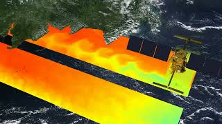
As well as surveying Earth’s freshwater bodies, the Swot satellite is set to pursue the mission of the Jason satellites, observing ocean circulation in two dimensions with a tenfold increase in resolution.
Swot oceanography data products will comprise sea-surface height data collected on each satellite pass.
The products consist of two swaths, each 58 km wide, and nadir data in the centre, extending from pole to pole.
Level 2 products have a resolution of 2 km by 2 km. If each swath is 58 km wide, data quality is degraded at the edges. The error due to instrument noise is still less than 2 cm between 10 and 60 km.
Level 2 expert products will also be available with a resolution of 500 m by 500 m but more noise. The sea-surface height error reaches 4 cm in the centre of the swath and 10 cm at the edges.
Oceanography products will come with the metadata required for users to process them, including geographic information, propagation correction and instrument bias, and geophysical and meteorological data.
Downloads
| File | Type | Size | Lang | Resolution | Creation date | Represented date |
|---|---|---|---|---|---|---|
| swot_ocean.jpg | Image | 11.9kb | 320x180 | 2019-10-01 | ||
| swot_ocean_products.pdf | Electronic document | 2.09Mb | en | 2019-10-01 | ||
| swot_ocean_products_sd.mp4 | Video | 14.8Mb | en | 2019-10-01 | ||
| swot_produits_ocean_fr.pdf | Electronic document | 2.1Mb | en | 2019-10-01 | ||
| swot_produits_ocean_fr_sd.mp4 | Video | 14.82Mb | en | 2019-10-01 |
- Geographic area : All oceans
- Instrument : Altimeter
- Parameter : Sea level anomalies, Dynamic topography
- Topic : Coastal applications, Large-scale Ocean circulation, Mesoscale Ocean circulation (eddies)
- Satellite : Swot