


ERS-2 mission reprocessing at CTOH for continental surfaces
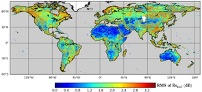
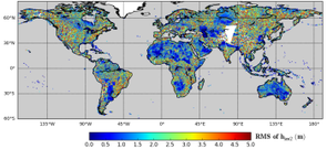
The Center for the Topography of Oceans and the Hydrosphere (CTOH) has reprocessed the original ERS-2 waveforms (WAP data) with a new implementation of the ICE-2 retracker algorithm. The new ERS-2 product includes new altimetric corrections that make it compatible and homogenous with the ENVISAT (v2.1) mission, and is tailored for continental surfaces, but with global coverage; this product provides a baseline for ERS-2/ENVISATv2.1 continuity and long-term altimetry data analysis (1995-2010).
The ERS altimetry data are historically distributed at level 2 only for open ocean applications. CTOH has created a new version of the LEGOS ERS altimetry processing chain (Legrésy and Rémy, 1997), and has conducted a reanalysis of the ERS-2 altimetry waveforms using WAP data kindly provided by ESA. This reprocessing of the ERS-2 waveforms (WAP data) included a new implementation of the ICE-2 retracker algorithm, with additional altimetric corrections to make ERS-2 data compatible and homogenous with the ENVISAT mission for continuity and long-term altimetry data analysis over land and ice sheets.
This processing contains the ICE-1 and ICE-2 retracking parameters and updated corrections. We have used GFZ precise orbits (Rudenko et al., 2014) for the period May 1995 - July 2003. We also computed a new dry troposphere correction with ERA-INTERIM fields valid over all surfaces (Blarel and Legresy, 2013) and a new Doppler correction accounting for the range rate (Blarel and Legresy, 2012). For each waveform parameter (range, backscatter, leading edge width and trailing edge slope) we computed empirical corrections to make them comparable to ENVISAT-v2.1. We produce a dataset providing continuity between the ERS-2 and ENVISAT missions (Blarel et al., 2015).
While this ERS-2 product focuses on continental surfaces, an alternative REAPER ERS-2 product exists, tailored for ocean applications (ESA Reaper, 2015); they are hence complementary.
Further information:
- CTOH web site: Access to the data, product handbook
References:
-
- CTOH. 2015. “Dataset: Altimetric data of the ERS-2 mission”. OMP-INSU-UPS-IRD. doi:10.6096/CTOH_ERS-2_2015_01.
- CTOH ERS-2 Product Handbook, 2015.
- Legrésy, B., Rémy, F, 1997. Surface characteristics of the Antarctic ice sheet and altimetric observations. Journal of Glaciology, 43(144), 197-206.
- Rudenko, Sergei, Denise Dettmering, Saskia Esselborn, Tilo Schöne, Christoph Förste, Jean-Michel Lemoine, Michaël Ablain, David Alexandre, et Karl-Hans Neumayer. 2014. “Influence of Time Variable Geopotential Models on Precise Orbits of Altimetry Satellites, Global and Regional Mean Sea Level Trends”. Advances in Space Research 54 (1): 92 118. doi:10.1016/j.asr.2014.03.010.
- Blarel, F., et B. Legresy. 2013. “Investigations On The Envisat Ra2 Tropospheric Correction”. ESA Living Planet. Edinburgh, United Kingdom.
- Blarel, Fabien, et Benoît Legresy. 2012. “Investigations On The Envisat Ra2 Doppler Slope Correction For Ice Sheets”. ESA-CNES symposium on altimetry Venice
- F. Frappart, B. Legrésy, F. Niño, F. Blarel, N. Fuller, S. Fleury, F. Birol, S. Calmant, 2016. “An ERS-2 altimetry reprocessing compatible with ENVISAT for long term land and ice sheets studies.” Remote Sensing of Environment.
- ESA Reaper product, 2015.
- Blarel, F., Frappart, F., Legrésy, B., Blumstein, D., Rémy, F., Fatras, C., Mougin E., Papa F., Prigent C., Nino F., Borderies, P., Biancamaria S, Calmant S., 2015. “Altimetry backscattering signatures at Ku and S bands over land and ice sheets.” Proceedings of SPIE Remote Sensing - Remote Sensing for Agriculture, Ecosystems, and Hydrology, 17, 963727, doi:10.1117/12.2194498.