


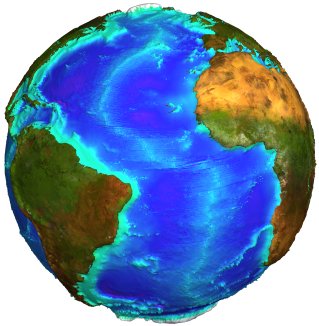
Bathymetry estimate from altimetry
Dense satellite altimeter measurements can be used in combination with sparse measurements of seafloor depth to construct a uniform resolution map of the seafloor topography. These maps do not have sufficient accuracy and resolution to be used for assessing navigational hazards, but they are useful for such diverse applications as locating obstructions/constrictions to the major ocean currents and shallow seamounts where fish and lobster are abundant. Detailed bathymetry also reveals plate boundaries and oceanic plateaus.
 Bathymetry can be computed using altimetry together with other data (Credits Cnes).See Interface 3D |
A detailed knowledge of topography is fundamental to the understanding of most Earth processes. In the oceans, detailed bathymetry is essential for understanding physical oceanography, biology and marine geology. Currents and tides are controlled by the overall shapes of the ocean basins, as well as by the smaller, sharp ocean ridges and seamounts. Sea life is abundant where rapid changes in ocean depth deflect nutrient-rich water toward the surface. Because erosion and sedimentation rates are low in the deep oceans, detailed bathymetry also reveals mantle convection patterns, plate boundaries, the cooling/subsidence of the oceanic lithosphere, oceanic plateaus and the distribution of off-ridge volcanoes.
Since it is impossible to map the topography of the ocean basins directly from Space, most seafloor mapping is a tedious process that is carried out by research vessels equipped with echo sounders. However, completely mapping the ocean basins at a horizontal resolution of 100 m would take about 125 ship-years of survey time using the latest technology, with highly non-uniform data. Thus, until recently, our knowledge of the seafloor topography was poor.
The free surface of the ocean deforms by tens of meters in places as a result of gravity differences caused by the relief of the seafloor and uneven mass distribution within the Earth's crust. Altimetry measurements, whose electromagnetic waves do not penetrate in-depth, is thus able to measure the sea-surface deformation due to the undulating bottom topography.
Radar altimeters aboard the ERS-1 and Geosat spacecraft have surveyed the marine gravity field over nearly all of the world's oceans with high accuracy and moderate spatial resolution. In March 1995, ERS-1 completed its dense (~8 km track spacing at the equator) mapping of sea surface topography between the latitudes of 81.5° North and South. These data have been combined and processed to form a global marine geoid or gravity grid [Cazenave et al., 1996; Sandwell and Smith, 1997]. In the wavelength band 15 to 200 km, gravity anomaly variations are highly correlated with seafloor topography and thus, in principle, can be used to recover topography.
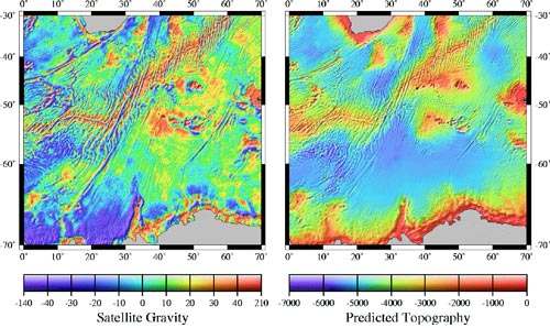
The basic theory for predicting seafloor topography from satellite altimeter measurements is summarised in a paper by Dixon et al. [1983]. The conceptual approach uses the sparse depth soundings to constrain the long-wavelength depth while the shorter-wavelength topography is predicted from the downward-continued satellite gravity measurements [Smith and Sandwell, 1994]. There are a number of complications that require careful treatment, e.g.:
- computing bathymetry from gravity anomalies is only possible over a limited wavelength band,
- longer wavelengths in this band are highly dependent on the elastic thickness of the lithosphere and/or crustal thickness,
- sediments favour filling bathymetric lows and can eventually completely bury the pre-existing basement topography.
References :
- Cazenave, A., P. Schaeffer, M. Bergé, and C. Brossier, High-resolution mean sea-surface computed with altimeter data of ERS-1 (Geodetic mission) and Topex/Poseidon, Geophys. J. Int., 125, 696-704, 1996.
- Dixon, T. H., M. Naraghi, M.K. McNutt, and S.M. Smith, Bathymetric prediction from Seasat altimeter data. J. Geophys. Res. 88, 1563-1571, 1983.
- Smith, W.H.F., and D.T. Sandwell, Bathymetric prediction from dense satellite altimetry and sparse shipboard bathymetry. J. Geophys. Res. 99, 21,803-21,824, 1994.
- Smith, W.H.F., and D.T. Sandwell, Global sea floor topography from satellite altimetry and ship depth soundings. Science 277, 1956-1961, 1997.
Further information :
- Bathymetry and currents in the Zapiola area Download the kml file and open it in Google Earth).
- Sandwell D.T. and W.H.F. Smith, Bathymetric estimation Satellite altimetry and Earth sciences, L.L. Fu and A. Cazenave Ed., Academic Press, 2001.
- Measured and estimated seafloor topography (UCSD, USA).
- Seafloors map from satellite altimetry, IRD editions.
- Interactive 3D interface to see a multi-faceted globe.
- Images of the month related to bathymetry :
- A glassy sea... of ridges and valleys, June 2001,
- Undersea mountains slow down Earth rotation, June 2002,
- Currents steered by gaps in the ridges, July 2003,
- Aviso Newletters related to bathymetry :
- # 3 : Assimilating Topex/Poseidon data into a numerical model of North Atlantic ocean circulation (J.Verron, 1994),
- # 6 : Marine gravity and small-scale ocean currents: effects of seafloor topography (D. Sandwell, 1998),
- # 8 : Gravity, Bathymetry, and Mesoscale Ocean Circulation from Altimetry (S. Gille, 2001).