


Positioning principle
The ability to precisely determine a satellite's position on orbit is a key factor in the quality of altimetry data. The Doris system, based on the Doppler effect, contributes to this delicate orbitography exercise .
Locating a satellite or a point on Earth involves calculating positional coordinates (and possibly velocities) in three dimensions within a given reference frame. Obviously, this frame is Earth-fixed since our aim is to use precise positioning data to study the oceans, crust, ice and other features. The origin of the reference frame is the Earth's center of mass, or geocenter.
Locating a satellite in space is complicated by the fact that it is in motion on a trajectory dictated by launch parameters and forces acting on the satellite. Chief among these forces are the pull of Earth's gravity, which keeps the satellite in orbit, and surface acceleration forces such as solar radiation pressure and atmospheric drag. That is why we need a good understanding of the Earth's gravity field and the satellite's environment to calculate the real trajectory with respect to the elliptical orbit described by Kepler's laws of motion. Lastly, positioning also relies on geodetic observation techniques.
Doppler effect
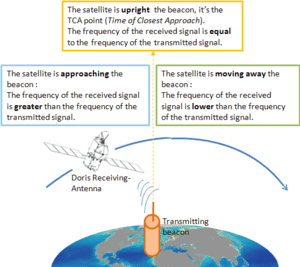
The Doris antenna onboard satellites receives signals emitted by the terrestrial stations network. When the receiver and the source are moving each other, the receiving wavelength differs from the emitting wavelength : it is the Doppler effect.
When the satellite moves closer to the emitting beacons, the frequency of the signal received by Doris instruments onboard the satellite is higher than one of the emitted signal, and lower when it moves away. If the emitting and receiving frequencies are equal, the emitting beacon is on the perpendicular to the satellite ground track. On a plot of the frequency received by the satellite as a function of time, the slope of the curve at the point of near maximum (TCA point: Time of Closest Approach) enables to calculate the distance between the beacon on the ground and the transmitting satellite.
The orbit calculation
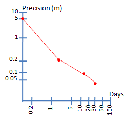
The precise orbit determination is not instantaneous. It requires measurements processing and the taking into account of environmental satellite (maneuvers, the physical forces of gravity and forces of atmospheric friction ...). The orbit is calculated by adjusting a model by minimizing differences between the measurements velocities obtained by Doris and those predicted by the model. The accuracy of this calculation increases with the accumulation of measurements so with the time : the accuracy is 10 cm RMS on the radial orbit for data up to three hours, 4 cm RMS for data up to three days, and 2.5 cm for data up to 30 days, with the goal to minimize it closer to 1 cm.
High-precision positioning
When the satellite position is precisely determined on its orbit, the Doris system can be used to locate a Doris ground beacon which is outside the reference network, at a point requiring temporary monitoring (volcanoes, geological faults, glaciers ...). This system is suitable for objects fixed or moving very slowly and is useful in the geophysics and geodesy fields (See Other geophysical applications).
Further information :
- Doppler measurement principle in A brief overview of Doris system evolutions (pdf, slide #4 and 5). P. Sengenes and al. , IDS workshop, 2002.
Techniques
 Altimetry .
- DORIS .
- Principle.
- DORIS system .
- DORIS applications.
- DORIS missions.
- Radiometry .