Altimetry close to the coast: technical issues & solutions
Why altimetry data needs specific processing in coastal ocean regions?
Altimeters take measurements all the time, so why should it be difficult to obtain good-quality data close to the coast?
There are several factors for this:
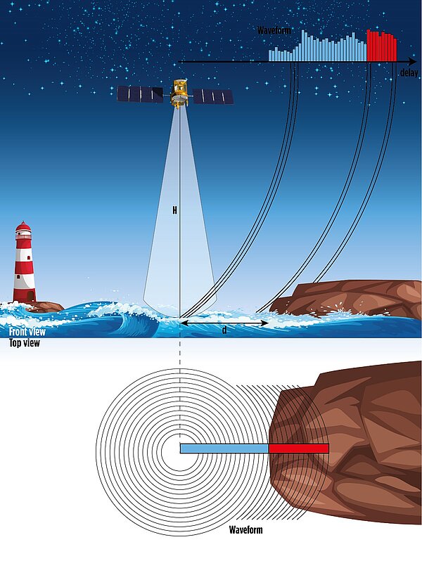
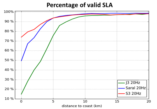
- the characteristics of the altimeter itself, since when approaching or leaving the coast, the surface observed, and therefore the reflected echoes (called waveforms), become a combination of signals from sea and land. As a general rule, only the echoes coming from the sea, which have a specific shape, are processed by ground segments. In practice, this means that altimeter data closer than about 10 km of any land surface could be "contaminated" and then rejected by ground segments. This does not mean that the corresponding altimeter data are lost, only that they require special coastal processing to analyze more complex forms of radar echoes.

- some of the corrections that need to be applied to altimetry measurements are very accurate offshore, but much less near the coast. This is particularly true of ocean tide correction. Ocean tides are becoming both larger and more complex over the continental shelf and near the shores, with the often-jagged geometry of the coasts, compared to the open sea. Thus, the tidal models, used to compute the ocean tide correction, require a high spatial resolution and a very precise knowledge of the coastal geography and local bathymetry in coastal regions. But this information, as well as such models, are not necessarily available. Similarly, the models used to calculate the high frequency atmospheric correction suffer from a lack of resolution near the coast, where the geophysical dynamics are much faster in space and time.
The ionospheric and dry tropospheric corrections may pose difficulties in transition zones between land and sea., The standard corrections applied to the altimetry measurement during such transitions do not always take correctly into account the change between the two types of surfaces.
The wet tropospheric corrections, computed from radiometer measurements are also less precise, or even missing, near the coasts, for the same reasons of land contamination as for the altimeter itself. In this case, models and coastal GNSS measurements can be used (see GPD+ data product)
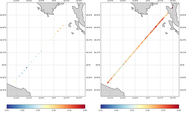
- the products themselves, designed for the open ocean, are not always suited for coastal waters. As an example, in the basic distributed data (GDRs or "level 2") the altimetry measurements and corrections are mainly averaged over one second ("1 Hz" data), thus encompassing about 7 km on the ground. Data averaged over 1/20 s do exist ("20 Hz" data), which lead to a measurement every ~350 m. Even if they are noisier than those averaged every second, they allow you to retrieve more information close to the coast. Moreover, the recent SAR-mode measurement capability of modern altimetry satellites allows to significantly reduce noise and therefore increase spatial resolution.
Solutions
To overcome the problems listed above, several approaches can be used, and ultimately combined. They now provide access to accurate coastal sea level anomalies. In particular, a number of studies have been led during the past years to find better waveform processing algorithms (retracking) close to the coast; Improvements of each of the different corrections in question have also been made by experts in every one of those fields. The use of 20 Hz data, possibly filtered, or lower resolution (but still higher than 1 Hz) has been explored. Specific products have been defined in collaboration with coastal users.
Related:
- ALTimetry Innovative Coastal Approach Product (Alticap) distributed by Aviso (including links to iPython notebooks)
- Coastal Altimetry Workshop
- Coastal Altimetry, S. Vignudelli et al. Eds, 2011 https://doi.org/10.1007/978-3-642-12796-0
- Videos
- Applications
SAR-altimetry
"SAR mode" altimetry, while using the same nadir radar-beam technology than conventional altimetry, enables to process the data in smaller units along the tracks by exploiting the Doppler shift depending on the reflection location (see Delay Doppler / SAR altimetry ). If the current distributed data are not of higher along-track resolution than the conventional ones (about 300 m – and no across track capabilities), they are more accurate at this resolution than the conventional altimetry. SAR altimetry is currently flying on Cryosat-2, Sentinel-3A & B and Sentinel-6 Michael Freilich.
Studies on fully-focused SAR processing, using the full duration of the signal coherence, show both good quality sea level anomalies and a better resolution in coastal areas. This kind of processing is still in an exploratory phase, and time-consuming.
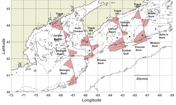
See e.g. Hui Feng, Alejandro Egido, Doug Vandemark, John Wilkin, Exploring the potential of Sentinel-3 delay Doppler altimetry for enhanced detection of coastal currents along the Northwest Atlantic shelf, Advances in Space Research, Volume 71, Issue 1, 2023; https://doi.org/10.1016/j.asr.2022.09.011 on coastal-dedicated FF-SAR processing
Swot: a new deal
With its swaths and 250-m resolution 2D data products, Swot is opening a whole new field for coastal altimetry. The technique is different enough at the radar altimeter level so as not to have the same land/water contamination problem. The geophysical and propagation corrections, though, are the same and thus have been the topic of many preparatory studies so as to be on a par with the mission’s spatial resolution.


