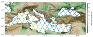
ALTimetry Innovative Coastal Approach Product (ALTICAP)
Types of dataset: Altimeter Sea Level Anomalies dedicated to coastal applications
DOI: 10.24400/527896/a01-2023.020 - more metadata
Contents: Jason-3 along-track delayed time corrected Sea level anomalies with corrections and auxiliary parameters (such as wind speed and Significant Wave Height).
Use: coastal applications
Description: Contains Experimental Jason-3 altimeter 20Hz along-track satellite coastal product in delayed time and global (from 0 to 500 km from the coast). This product has been developed with the goal of providing simple and easy-to-use files with a resolution consistent with the observable physical signal. The given Sea Level Anomaly (SLA) has been corrected with standard corrections. Those corrections are provided in the files so that users can apply their own correction. Some fields from the level 2 product (L2) such as altimetric wind speed and significant wave height are also provided to facilitate certain applications. Two types of datasets are distributed: 1/a dataset of one file per day containing one day of measurements for several tracks, and 2/ a dataset of one file per track containing the time series over the whole period.
The ALTimetry Innovative Coastal Approach Product has been developed following a round robin study aimed at comparing 21 algorithms used for calculating sea level anomalies (SLA) from altimetry in low resolution mode (LRM) and targeting the ocean region between 0 and 200 km from the coast.
In the following document you will find the complete protocol followed during the Round Robin study mentioned above, as well as access to all the results obtained (reports here): RoundRobinSpecificationPlan_v5.pdf
But please note that the processing solution adopted here is a compromise between:
- The capability of each algorithm (correction or parameter) to provide the best SLA over the entire strip between 0 and 200 km from the coast (and not necessarily in the most coastal zone) to ensure continuity with the open ocean.
- The availability of the correction or parameter on several altimetry missions
- A guarantee of product continuity in the future.
Format: NetCDF
Tools:
- User handbook
- Example of python notebooks to read the files and plot several types of figures
- notebook for reading daily along-track files: reading the file, use the validation flag for plotting on a map or a track, selection of time, geographycal, track, distance to coast. Download the report of exemples here and the jupyter notebook coastal20Hz_along-track.ipynb
- notebook with examples of daily files and in situ data
- notebook for reading time series files with: examples of plotting on a map or in 2D; access to variables; time manipulation. You need to download the file dt_coastal_j3_phy_20hz_t001.nc via ftp/sftp or TDS and download the report of exemples here and the jupyter notebook exple_read_data.ipynb)
- See Altimetry close to the coast: technical issues & solutions for an overview of the technical questions raised by altimetry near the coasts, and Ocean coastal applications for the possible use of it.
Geographic coverage: Global (0-500km from coast)
Citation: This product has been developped, validated by CTOH/LEGOS, CLS France and Noveltis with support from CNES. Publications should include the following statement in the Acknowledgments: “ALTimetry Innovative Coastal Approach Product (ALTICAP) used in this study (DOI 10.24400/527896/a01-2023.020) was funded by CNES, developed and validated by the CTOH/LEGOS, CLS and Noveltis and CLS and distributed by AVISO+”.
Copyright : CNES/CTOH/LEGOS/CLS/Noveltis
| for the registration to Aviso products and select the product "ALTimetry Innovative Coastal Approach Product (ALTICAP)" |
ALTimetry Innovative Coastal Approach Product (ALTICAP)
| Satellite | Area | Type | Authenticated access service | Data period | File weight |
|---|---|---|---|---|---|
| Jason-3 | Global (0-500km from coast) | along-track daily files | please refer to MY AVISO+ and select the product "ALTimetry Innovative Coastal Approach Product (ALTICAP)" | Feb 2016 - Jul 2021 | <35 Mb |
| timeseries files | <118 Mb |


