


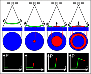
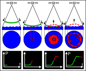
Pulses and waveforms
The radar altimeter emits a pulse towards the Earth's surface. The time which elapses from the transmission of a pulse to the reception of its echo reflected off the Earth's surface is proportional to the satellite's altitude. The magnitude and shape of the echoes (or waveforms) also contain information about the characteristics of the surface which caused the reflection.
Pulses reflection
Over an ocean surface, the echo waveform has a characteristic shape that can be described analytically (the Brown model). Surfaces which are not homogeneous, which contain discontinuities or significant slopes, such as some land surfaces, make accurate interpretation more difficult.
Waveforms characteristics
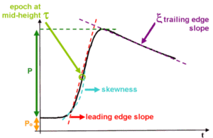
From the basic waveform shape, several parameters can be deduced :
- epoch at mid-height : this gives the time delay of the expected return of the radar pulse (estimated by the tracker algorithm) and thus the time the radar pulse took to travel the satellite-surface distance (or 'range') and back again.
- P: the amplitude of the useful signal. This amplitude with respect to the emission amplitude gives the backscatter coefficient, sigma0.
- Po: thermal noise
- leading edge slope: this can be related to the significant wave height (SWH)
- skewness: the leading edge curvature
- trailing edge slope: this is linked to any mispointing of the radar antenna (i.e. any deviation from nadir of the radar pointing).
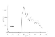
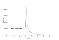
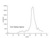
Examples of real waveforms from the Topex altimeter : waveforms over ocean (left), on a river (middle) and over land (right).
Waveforms on ocean are quite typical of its class since the echo is exclusively reflected by the water. But waveforms on others surfaces include a wide variety of configurations which are difficult to process. Analyses from waveforms over heterogeneous surfaces enable to retreive several parameters and deduced other interesting characteristics.
Thus, the backscatter coefficient (sigma0) is useful to characterize the surface : a low value for mountainous regions and high value on flat surfaces or wetlands. The bacscatter coefficient can also be related to the dates when a surface is completely frozen, when the ice breaks up, and fast-ice duration (see Image of the month, May 2006, Ice on Lake Baikal).
The leading edge width is related to the penetration into the medium and the surface roughness of the target. The leading edge width values are high in desert areas due to the strong penetration of the wave and the dunes generated by the winds. Low values, related to weak penetration, correspond to dense vegetated areas, such as tropical or boreal forests, or to large river basins or flooded regions.
Retracking for heterogeneous surfaces
Over continental areas, the altimeter footprint is frequently contaminated by the multiplicity of surfaces. This contamination has important consequences on the complexity of the waveform (for example, many radar echoes are multipeaked) and on the accuracy of measurements.
Thus, all altimeter data for heterogeneous surfaces must be post-processed to produce accurate surface elevation measurements. This post-processing is called 'retracking' and is required because the leading edge of the ice-sheet return waveform deviates from the on-board altimeter tracking gate.
Topex/Poseidon altimeter measurements on Amazon river near Manaus : in red, only 13 measurements are kept by the ocean processing and presented in the GDR; in yellow, all altimeter measurements are recovered by the post-processing commonly called retracking. Credits CLS.