


Better gravity with drifting orbits
Image of the Month - May 2015
Bathymetry is the study of the ocean depths. It is often said that the ocean depths are less known that the surface of the Moon. And, indeed, it is easier to measure topography in the air (or even better without air) than underwater, since the electromagnetic waves do not penetrate far into the waters. The alternate is sound, with sonar, but have to be done by boats (not by satellite nor plane nor drone), which have to come and criss-cross the whole area to map. It is time-consuming, very costly and not always feasible.
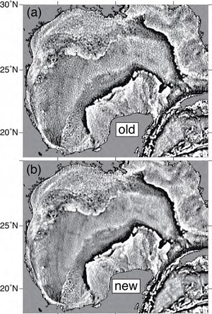
However, satellites can help. Altimetry satellites measure the geoid plus ocean dynamic topography. Geoid depends on the gravity field, and thus on a (small) part on the sea floor topography. It is not easy to reconstruct the bottom topography from the surface's, since the seafloor density plays a role, too. You can have undersea mountains buried in sediments. The mountains will show on the altimetry measurements, not the plain. On another side, the mountains can be a fracture zone, interesting to pinpoint for plate tectonics. Anyway altimetry enable to measure the gravity of the seafloor.
But, usually, the altimetry satellites take measurements following a wide mesh (e.g. distance between two Jason ground tracks at the Equator is 315 km), thus missing entire areas. With "drifting" (also called "geodetic") orbits, the tracks are not repetitive, but are very close to each others. Thus a much denser mesh of measurements can be taken, with many more details. Jason-1 was put on such an orbit between March 2012 and June 2013. It is the case for Cryosat-2 since its launch in April 2010.
See also:
- Applications: Geodesy & geophysics
- Images of the month related to geodesy :
- Ocean ridges, December 2002,
- Ocean circulation with gravity, May 2004.
- Aviso Newsletter 8 : Gravity, Bathymetry, and Mesoscale Ocean Circulation from Altimetry (S. Gille)
- Aviso Newsletter 6 : Marine gravity and small-scale ocean currents: effects of seafloor topography (D. Sandwell)
Websites on this subject:
News
 Archives .
- Aviso Newsletter .
- Search.
- Front-page news.
- Image of the month .
- 2026 .
- 2025 .
- 2024 .
- 2023 .
- 2022 .
- 2021 .
- 2020 .
- 2019 .
- 2018 .
- 2017 .
- 2016 .
- 2015 .
- Dec. 2015: Multi-year penguin tracking.
- Nov. 2015: Saral measures gaps in sea ice.
- Oct. 2015: A future insight to English Channel.
- Jul. 2015: El Niño's return, West side story.
- Jun. 2015: Current intruding on the continental shelf.
- May 2015: Better gravity with drifting orbits.
- Apr. 2015: Through Indonesia.
- Mar. 2015: High tides at Mont Saint-Michel.
- Feb. 2015: Small fishes in a big ocean.
- Jan. 2015: El Niño played hide and seek in 2014.
- 2014 .
- 2013 .
- 2012 .
- 2011 .
- 2010 .
- 2009 .
- 2008 .
- 2007 .
- 2006 .
- 2005 .
- 2004 .
- 2003 .
- 2002 .
- 2001 .
- 2000 .
- 1999 .
- 1998 .
- Operational news and status .