


Thule Doris station's rising at different velocities
Image of the Month - February 2016
The Earth is constantly changing shape. To be understood, when the motion of the Earth's crust is observed, it must be referenced. A Terrestrial Reference frame provides a set of coordinates of some points located on the Earth's surface. It can be used to measure plate tectonics, regional subsidence or loading and/or used to represent the Earth when measuring its rotation in space. Nowadays, four main geodetic techniques are used to compute accurate coordinates: the GPS, VLBI, SLR, and Doris. The International Terrestrial Reference Frames (ITRF) coordinates are obtained by combination of individual solutions computed by analysis centers using the observations of the four Space Geodesy techniques. They all use networks of stations located on sites covering the whole Earth. The ITRF is constantly being updated (the latest is the ITRF2014). All its releases include station positions and velocities. They model secular Earth’s crust changes.
For the Doris contribution to the International Terrestrial Reference Frame 2014, the Combination Center of the International Doris Service (IDS) estimated a new version of the coordinates time series of all the Doris station over the 1993-2015 time span. That new set of coordinates is the result of the combination of the individual solutions from the six IDS Analysis Centers.
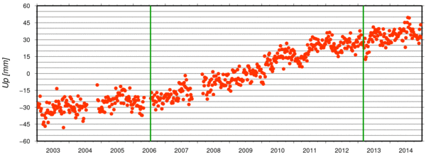
As preliminary step of the estimation of very precise mean positions and mean velocities, the Doris station coordinates time series were investigated, looking for significant discontinuities and change of velocities. The Thule station is especially interesting, with Greenland glacier melt a major concern. We already had a look at it in these pages (Image of the Month, June 2013), and noticed its general dynamics. However, it seems that the mean trend is not the whole story, and several phases can be seen if measurements are closely studied. Vertical velocities at coastal sites are critical as they may impact the study of local sea level variations through the analysis of the co-localized tide gauge records (e.g. a local level as measured by a tide gauge might be decreasing because the land is rising). Doris station data analysis, and the contribution to ITRF enable to closely monitor such variations and try and understand them.
See also:
- Doris
- Image of the Month, October 2009: Dumont d'Urville movements measured by Doris
- Applications: Other geophysical applications
- Calval: In situ global statistics - Tide gauges
Websites on this subject:
- Doris
- Presentation of Doris (Cnes)
- International Doris Service (IDS)
including interactive Tools to plot Doris locations time series
- Grace
- The Grace Plotter (GRGS)
References
- Moreaux, G., Lemoine, F.G., Capdeville, H., et al., 2016. The International DORIS Service contribution to the 2014 realization of the International Terrestrial Reference Frame. Advances in Space Research, In press, doi: 10.1016/j.asr.2015.12.021.
News
 Archives .
- Aviso Newsletter .
- Search.
- Front-page news.
- Image of the month .
- 2025 .
- 2024 .
- 2023 .
- 2022 .
- 2021 .
- 2020 .
- 2019 .
- 2018 .
- 2017 .
- 2016 .
- Dec. 2016: Testing Algorithms.
- Oct. 2016: A typhoon seen by satellites.
- Sep. 2016: The Silent World disturbed by icebergs' noise.
- Aug. 2016: It's raining under Jason-3.
- Jul. 2016: Elephant seals and macaroni penguins follow threads.
- June 2016: Turning around in the Lofoten eddy.
- May 2016: Readying for SWOT data to be used in hydrology applications.
- Apr. 2016: One thousand drifters and one (future) satellite in the Gulf of Mexico.
- Mar. 2016: Storm in the Bay of Biscay.
- Feb. 2016: Thule Doris station's rising at different velocities.
- Jan. 2016: The 2015 El Niño: An extraordinary Modoki event?.
- 2015 .
- 2014 .
- 2013 .
- 2012 .
- 2011 .
- 2010 .
- 2009 .
- 2008 .
- 2007 .
- 2006 .
- 2005 .
- 2004 .
- 2003 .
- 2002 .
- 2001 .
- 2000 .
- 1999 .
- 1998 .
- Operational news and status .