


Katrina 2005: hurricane intensification
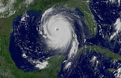
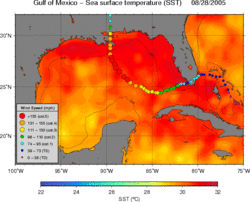
Hurricane Katrina devastated coastal areas of Louisiana and Mississippi causing the flooding of New Orleans in late August 2005. Sea Surface temperatures on August 28, 2005, in the Gulf of Mexico exhibited values larger than 26°C, a necessary but not sufficient condition needed to create and sustain a hurricane, over most of the Gulf.
Because the sea surface temperatures are mostly homogeneous throughout the region, they do not reveal warm and deep features, such as the Loop Current (cf Image of the Month, April 2003 : A looping current) and its associated anticyclonic (warm) rings, which have temperatures larger than 26°C reaching depths of tens of meters. On the other hand, satellite altimetry can easily identify these features as positive sea height anomalies .
After hurricane force winds erode the sea surface temperatures by mixing the surface waters with cooler deeper waters, the eye of the hurricane (the only part of the hurricane that takes energy from the ocean) 'sees' temperatures of the mixed layer. For most of the Gulf, this temperature probably decreases below 26°C, while for the Loop Current and warm rings it remains above 26°C, highlighting the fact that they are very large reservoirs of heat which remain in the Gulf of Mexico for long periods of time.
The Loop Current and warm rings are believed to have an influence on hurricane intensification, and even on hurricane trajectories. However, further analysis of atmospheric and ocean observations (including those obtained from altimetry) and models of this hurricane will be necessary to establish the precise role that the ocean played in the intensification of Katrina in the Gulf of Mexico. These type of studies will aid decision makers by providing more accurate information to give advance warning to inhabitants in coastal areas.
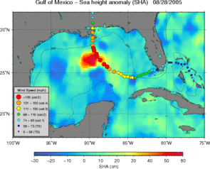
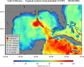
Sea level anomalies (left) and hurricane heat potential computed from altimetry (right) on August 28, 2005, with trajectory and intensity of Katrina overlayed. Intensification of Katrina seems to match its crossing over the Loop current. (Credits Noaa/AOML).