Mobile version

Drawing formal mapping error maps

Lively Data: May 19, 2009

In Near Real-Time, the Live Access Server gives access to Maps of Sea Level Anomalies for each altimeter mission with its formal mapping error. These maps are expressed in percentage of signal variance and allow to estimate the relative errors made by the mapping process. Recently, the LAS also integrates the NRT Jason-2 products.

A comparison on maps of merged SLA before/after the Jason-2 integration shows a formal error decreasing with the Jason-2 contribution. A second comparison on maps of SLA with/without merged data shows the large benefit provided by the multi-satellite configuration.

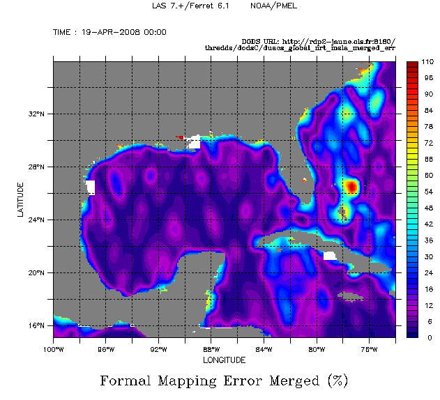
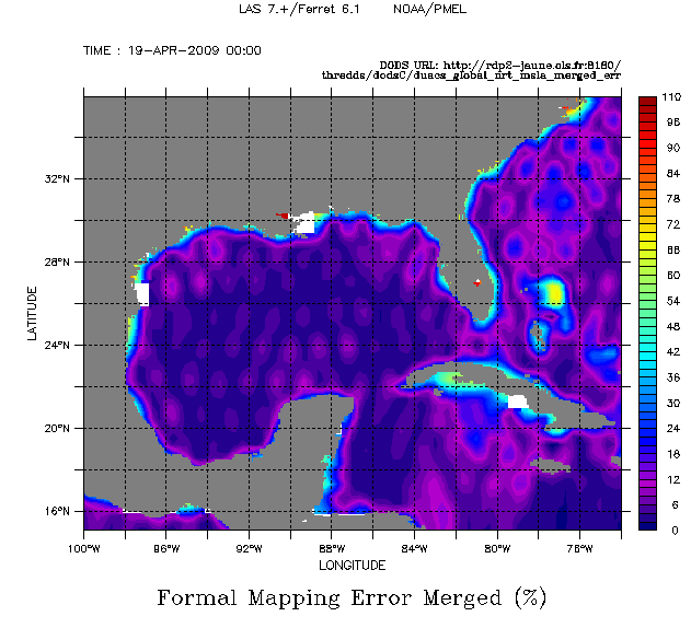
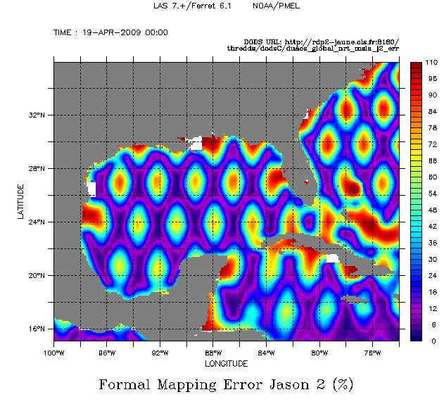
Maps of SLA Formal Mapping Errors expressed in % for merged data (left and middle) and Jason-2 monomission data (right). From left to right, maps date from April 2008 -before the Jason-2 integration (left) and from April 2009  -after the Jason-2 integration (middle and right). To plot such a map, you have to select the dataset  NRT - Global - (Maps of) Sea Level Anomalies And Formal Mapping Error  and Maps of Sea Level Anomalies Merged  (or Maps of Sea Level Anomalies Jason-2), choose the dates and define a common color fill levels (0,100,2)(110).

Further information:

EnglishFrançais
Rss feedsContactPartnersFAQLexiconLegal noticePersonal Data Protection PolicyMobile
You must enable cookies in your browser preferences to save the modifications
You are using an older version of Internet Explorer, please update to take full advantage of Aviso+ features

Customize the home page

View all widgets
Reduce display
Public profile
User profile

Select/Deselect widgets

Discover AVISO+

Customizable home, reading tools, products search guide, etc.. Discover step by step the features of the new site AVISO+.

Customizable homepage

This home page is composed of blocks called "widgets".

Rearrange the blocks with a "Click & Drop".

Hide a widget with the cross at the top right. Reset or add a widget with the "wrench" icon. The "User" and "Public" profiles offer a predefined organization.

All the modifications are automatically saved as cookies on your machine so as to enable you to have your own specific AVISO+.

Reading tools

Ease your reading by choosing the page background colour (black/white) and/or by modifying the font size.

Browsing menu and breadcrum trail

To ease your browsing through AVISO+, you can use at any time the main banner items with the interactive submenus or use the browsing menu on the left side of the screen (it is open by default). For more readiness of the page contents, you can fold and unfold the browsing menu by clicking on the tab. At any time you can know where you are thanks to the browsing menu or the breadcrum at the top of the page.

Products search guide

The first submenu of the "Data" banner item leads you to a new search form enabling you to find quickier the product that suits your needs. The list of results is updated according to your selection criteria.

AVISO+ Multimedia

The first submenu of the "Multimedia" banner item leads you to AVISO+ collections of images and videos linked to altimetry and its applications. Have a nice visit!