


Barystatic and manometric sea level changes from satellite geodesy
Barystatic and manometric sea level changes represent the mass component of sea level changes at global and regional scales respectively. Barystatic and manometric sea level changes are estimated here using two different approaches:
- satellite gravimetry measurements from the GRACE and GRACE-FO missions
- a sea level budget approach combining satellite altimetry with in-situ measurements of the seawater temperature and salinity.
The satellite gravimetry solutions were calculated using an ensemble approach updated from Blazquez et al., (2018) (GRACE L3 CNES V1.6 : link to cluster Form@ter in preparation), allowing to estimate the uncertainties associated with processing and post-processing choices. The sea level budget approach was adapted from Barnoud et al., (2023).
Barystatic sea level changes
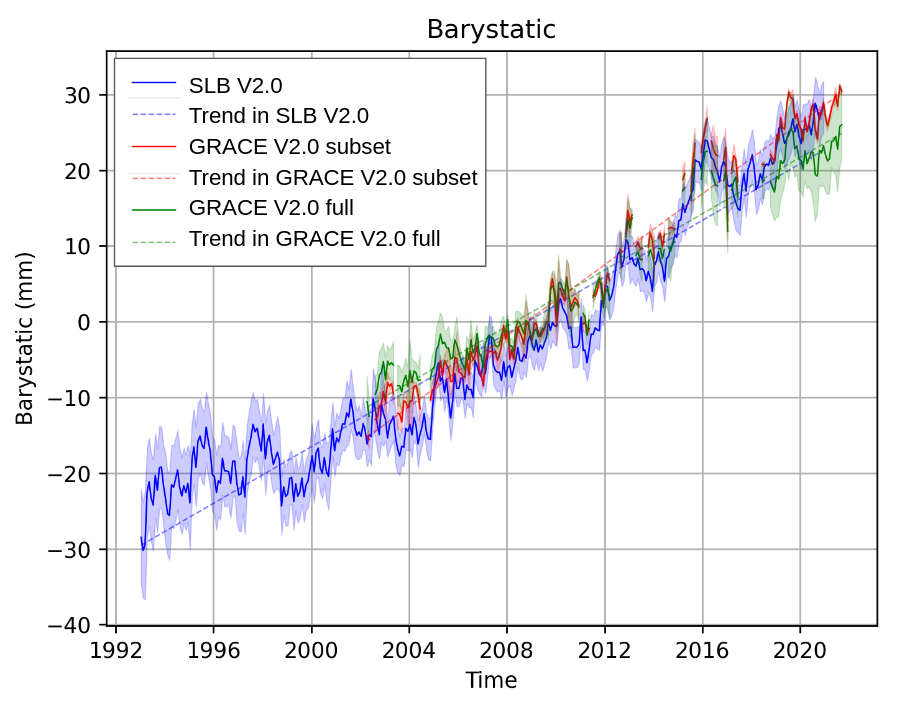
Barystatic sea level changes are due to freshwater exchanges with the continents, including ice mass changes from Greenland, Antarctica and continental glaciers, as well as freshwater fluxes from continental areas (i.e. large river basins such as the Amazon or Mississippi). Here, barystatic sea level changes estimated with satellite gravimetry are compared with the sea level budget approach, showing remarkable consistency (Figure 1). Barystatic sea level changes from satellite gravimetry are found to be highly sensitive to post-processing corrections, such as the geocenter and glacial isostatic adjustment, some models providing a better fit than others with the sea level budget approach.
Manometric sea level changes
Manometric sea level changes are due to several processes, including the atmosphere - ocean circulation, sea level fingerprints or global water cycle. Climate modes, such as the El Nino Southern Oscillation, Arctic Oscillation, North Atlantic Oscillation or Southern Annular Mode, have also been shown to significantly influence manometric sea level changes (e.g. Pfeffer et al., 2022).
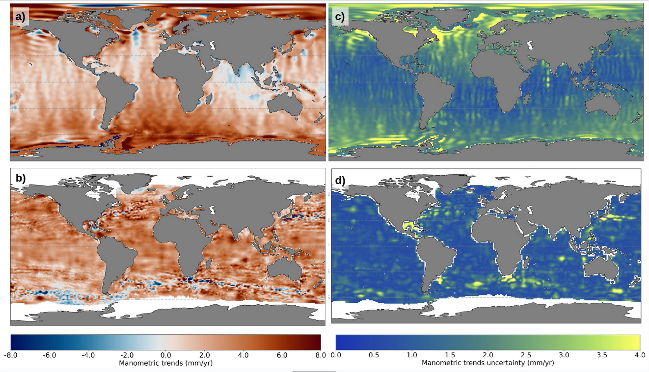
The trends in manometric sea level changes and their uncertainties are compared for the satellite gravimetry and sea level budget approaches (Figure 2). Trends are in good agreement over the Pacific, South Atlantic and South Indian oceans. The main differences are observed in the North Atlantic, North Indian Ocean, as well as in turbulent ocean areas, such as the Gulf Stream, Kuroshio and Southern Ocean, which may be explained by uncertainties in satellite gravimetry (North Atlantic and North Indian) and sea level budget (turbulent areas) approaches.
Barystatic and manometric products
In total, 4 products are distributed including:
- Barystatic sea level changes from satellite gravimetry with uncertainties at 1-sigma: monthly time series from April 2002 to August 2022
- Manometric sea level changes from satellite gravimetry with uncertainties at 1-sigma: monthly grids with 1 degree spacing from April 2002 to August 2022
- Barystatic sea level changes from sea level budget with uncertainties at 1-sigma: monthly time series from January 1993 to December 2020
- Manometric sea level changes from sea level budget with uncertainties at 1-sigma: monthly grids with 1 degree spacing from January 1993 to December 2020
DOI and metadata
The satellite gravimetry products are referenced with the DOI: https://doi.org/10.24400/527896/a01-2023.011
More metadata: https://commons.datacite.org/doi.org/10.24400/527896/a01-2023.011
The sea level budget products are referenced with the DOI: https://doi.org/10.24400/527896/a01-2023.012
More metadata: https://commons.datacite.org/doi.org/10.24400/527896/a01-2023.012
Product access and condition of access
The product (NetCDF file) can be downloaded in open acces on the https server or via the non authenticated FTP download (if the FTP protocol is not supported by your browsers, see this note)
The product is available free of charge for any project or study, and delivered as stated in the licence agreement.
Citation
If you use the data, please cite: "The barystatic and manometric products from satellite gravimetry and sea level budget approaches (DOI: 10.24400/527896/a01-2023.011 and 10.24400/527896/a01-2023.012) were produced by Magellium/LEGOS and distributed by AVISO+ (https://aviso.altimetry.fr) with support from Copernicus Marine Service. "
Contacts
For any technical issues or additional information related to the barystatic and manometric products, users are advised to contact Julia Pfeffer: julia.pfeffer(at)magellium.fr
Acknowledgment
This work is supported by CMEMS (Copernicus Marine Environment Monitoring Service) in the framework of the WAMBOR (WAter Mass Balance in Ocean Reanalyses) project: https://marine.copernicus.eu/about/research-development-projects/2022-2024/WAMBOR. CMEMS is implemented by Mercator Ocean International in the framework of a delegation agreement with the European Union.
Barystatic and manometric product versions, documentation and access
| Name | Version | Publication date | Input Data | Temporal coverage | DOI | Product user manual | Product access | |
|---|---|---|---|---|---|---|---|---|
| HTTPS | FTP | |||||||
| Barystatic and manometric from satellite gravimetry | 2.0 | July 2023 | GRACE L3 CNES V1.6 updated from Blazquez et al., (2018) | April 2002- August 2022 | 10.24400/527896/a01-2023.011 | PUM v2.0 | open access | non authenticated ftp |
| Barystatic and manometric from sea level budget | Satellite altimetry gridded sea level anomalies from C3S (Legeais et al., 2021) Temperature and salinity grids from EN4 (Good et al., 2013), IAP (Cheng et al., 2017, 2020) and Ishii et al., (2017). | January 1993 - December 2020 | 10.24400/527896/a01-2023.012 | |||||
Main references
- Blazquez, A., Meyssignac, B., Lemoine, J.-M., Berthier, E., Ribes, A., Cazenave, A. (2018). Exploring the uncertainty in GRACE estimates of the mass redistributions at the Earth surface: implications for the global water and sea level budgets, Geophysical Journal International, 215 (1), 415–430, https://doi.org/10.1093/gji/ggy293
- Barnoud, A., Pfeffer, J., Cazenave, A., Fraudeau, R., Rousseau, V., and Ablain, M. (2023). Revisiting the global mean ocean mass budget over 2005–2020, Ocean Sci., 19, 321–334, https://doi.org/10.5194/os-19-321-2023
Other references
- Cheng, L., Trenberth, K. E., Fasullo, J., Boyer, T., Abraham, J., and Zhu, J. (2017). Improved estimates of ocean heat content from 1960 to 2015, Science Advances, 3, https://doi.org/10.1126/sciadv.1601545
- Cheng, L., Trenberth, K. E., Gruber, N., Abraham, J. P., Fasullo, J. T., Li, G., Mann, M. E., Zhao, X., and Zhu, J., (2020). Improved Estimates of Changes in Upper Ocean Salinity and the Hydrological Cycle, Journal of Climate, 33, 10 357–10 381, https://doi.org/10.1175/jcli-d-20-0366.1
- Good, S. A., Martin, M. J., and Rayner, N. A. (2013). EN4: Quality controlled ocean temperature and salinity profiles and monthly objective analyses with uncertainty estimates, Journal of Geophysical Research: Oceans, 118, 6704–6716, https://doi.org/10.1002/2013jc009067.
- Ishii, M., Fukuda, Y., Hirahara, S., Yasui, S., Suzuki, T., and Sato, K. (2017). Accuracy of Global Upper Ocean Heat Content Estimation Expected from Present Observational Data Sets, SOLA, 13, 163–167, https://doi.org/10.2151/sola.2017-030
- Legeais, J.-F., Meyssignac, B., Faugère, Y., Guerou, A., Ablain, M., Pujol, M.-I., Dufau, C., and Dibarboure, G., (2021). Copernicus sea level space observations: a basis for assessing mitigation and developing adaptation strategies to sea level rises, Front. Mar. Sci., 8, 704721, https://doi.org/10.3389/fmars.2021.704721
- Pfeffer, J., Cazenave, A. & Barnoud, A. (2022). Analysis of the interannual variability in satellite gravity solutions: detection of climate modes fingerprints in water mass displacements across continents and oceans. Clim Dyn 58, 1065–1084. https://doi.org/10.1007/s00382-021-05953-z
Data
- Products guide.
 Products .
- Sea surface height products .
- Value-added products .
- Wind/wave products .
- Auxiliary products .
- Ice products .
- Ocean indicators products .
- El Niño bulletin .
- Mean Sea Level .
- Kuroshio .
- Ocean Heat Content and Earth Energy Imbalance .
- Barystatic and manometric sea level changes from satellite geodesy.
- Ionian Sea circulation.
- Ocean data challenges .
- In-situ products .
- Data access .
- Tools .
- Product information .
- CALVAL .
- Operational information .