


Doris on Envisat
The Doris instrument onboard Envisat provides real-time location and precise orbit determination. Doris measurements are also used for geophysical studies, in particular through the International Doris Service (IDS). Doris is a dual-frequency instrument able to determine atmospheric electron content.
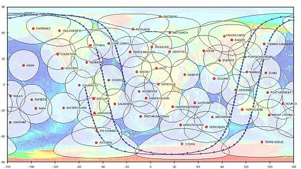
To perform its missions of satellite orbit restitution and ground beacon location, the Doris system comprises an onboard package, a network of beacons, and the Doris Control and Data Processing Centre. For operational aspects, the Doris control centre provides an interface with the satellite flight operation segment. The orbit determination beacons are deployed throughout a dense worldwide network. This network is deployed and maintained by the IGN (French national geographic institute). The time reference for the system is provided by master beacons located in Toulouse, France and Kourou, French Guiana, which are connected to atomic clocks. The Doris onboard instrument package consists of :
- a redundant receiver with two receiving chains;
- an ultrastable crystal oscillator (USO) identical to the USOs employed in the Doris ground segment;
- an omnidirectional dual-frequency antenna;
- an Instrument Control Unit (shared with the MWR).
The receivers can track two beacons simultaneously.
The Doppler measurements are also processed on board to obtain real time orbit data with lower accuracy.
Function
Doris is based upon the accurate measurement of the Doppler shift of radio frequency signals transmitted from ground beacons and received on board the satellite. Measurements are made at two frequencies : 2.03625 GHz for precise Doppler measurements and 401.25 MHz for ionospheric correction of the propagation delay. The 401.25 MHz frequency is also used for measurement time-tagging and auxiliary data transmission. The selection of an uplink-only system allows fully automated operation of the beacons and easy communication links for the overall system, data being centralised through the satellite and its ground segment to the Doris data processing centre. The control and data processing centre is located in Toulouse, France, and operated by CLS.
Precise orbit determination
Doris measurements are used for precise orbit determination (POD). Onboard measurements of the Doppler shift are performed every 10 seconds. The resulting radial velocity values (accurate to the order of 0.4 mm/s) are used on the ground in combination with a dynamic model of the satellite's trajectory to perform precise orbit determination with an accuracy of greater than 5 cm in altitude. These orbit data are available with a time lag of 1.5 months, with the delay being mainly due to the availability of external data, such as solar flux.
Real-time location: Diode
The Doppler measurements are also processed on board to obtain real-time orbit data with lower accuracy. The Diode onboard navigator locates the satellite on orbit in real time. This information is essential for providing altimetry data in real time or near-real time.
Ionospheric electron content
By measuring and comparing the path delay of signals transmitted at two separate frequencies, Doris is able to calculate the electron content in the atmosphere. This information is then used to determine perturbations acting on the altimeter's radar signal.
This function complements the dual-frequency altimeter function.
Principle
Doris orbitography beacons transmit signals at two separate frequencies (2,036.25 MHz and 401.25 MHz) to the satellite. The receiver onboard the satellite analyses the received signal frequencies to calculate its velocity relative to Earth. This velocity is fed into orbit determination models to derive the satellite's position on orbit to within two centimetres on the radial component.
Every 10 seconds the receiver measures the Doppler shift of the signals continuously transmitted from the ground beacons at the two frequencies of 2,036.25 MHz and 401.25 MHz. The onboard ultra-stable oscillator provides the reference for this measurement with a stability of 5x10-13 over 10 to 100 seconds. Both frequencies are susceptible to group-delay caused by propagation through the ionosphere, but the effects are much greater at the lower VHF frequency (being inversely proportional to the square of the frequency). Thus these measurements can be used to obtain a correction for the higher frequency.
Further information :
- Doris on this Aviso website.
- International Doris Service (IDS).
- The Doris instrument onboard Envisat (Esa website).