


Altimetry helps in coastal flood risk warning
Image of the Month - November 2023
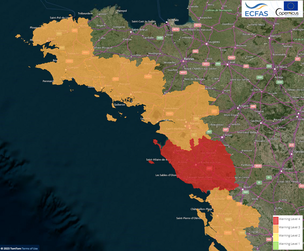
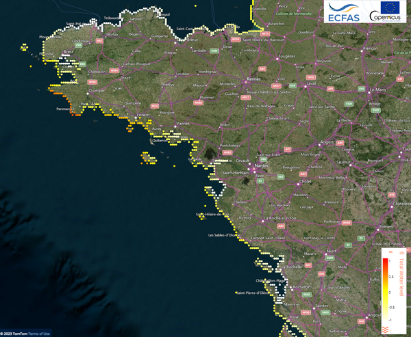
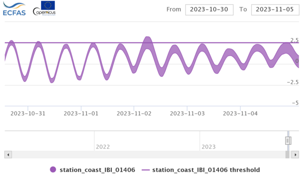
Coastal flood warning (at the administrative scale), coastal total water level ("total" sea level including DAC & tides heights, but also waves impact, aka "wave set-up"). Total water level and water level without wave set-up in one of those point on October 31st (Les Sables d'Olonne). Credits CLS for Ecfas project.
Three major storms hit the western Europe coasts from October 26 to November 5, 2023. Winds blew up to extreme values over lands, breaking records, waves were "very high" and up to "phenomenal" (SWH over 9 and 14 m resp.) in the open ocean. However, another possible threat generated by such storms is the coastal submersion. With low atmospheric pressure increasing sea levels, increase in mean water level due to the presence of strong breaking waves (wave setup) plus possibly high tides, coastal towns and infrastructures can be severely flooded. During the latest series, tides were not especially high, which mitigated the impact. Coastal erosion, though, did occur.
Those information can be extracted from altimetry datasets, although not in every point of the world coasts, nor at every time it would be needed. Models are used to propagate altimetry-retrieved measurements -- ocean circulation models for the sea level, tides & atmospheric ones for the tides and atmospheric pressure, wave models for the wave heights.
The Ecfas (European Coastal Flood Awareness System) prototype was developed in 2021-22 in the framework of an EU H2020 project dedicated to the Copernicus Emergency Management Service evolution. After the demonstration phase that ended in 2022, the system and web platform were kept active in 2023. Some past cases together with daily warnings using models assimilating altimetry data are provided.
See also:
- Data: Global FES tide model, DAC
- Applications: Coastal applications
- Image of the Month, Aug. 2023: assessing coastal vulnerability in Ghana
Other web sites on this topic:
- Ecfas project web site
News
- Search.
- Front-page news.
 Image of the month .
- 2024 .
- 2023 .
- Dec. 2023: Mega-icebergs seen by Swot.
- Nov. 2023: Altimetry helps in coastal flood risk warnings.
- Oct. 2023: Swot scans the Southern Ocean.
- Sep. 2023: Sea Ice variations around Antarctica.
- Aug. 2023: Assessing coastal vulnerability in Ghana.
- Jul. 2023: Detecting eddies around Antarctica.
- Jun. 2023: Doris validates GNSS-based ionospheric models.
- May 2023: Swot in an Estuary-River system.
- Apr. 2023: Calibrating Swot over the oceans.
- Mar. 2023: A new Mean Dynamic Topography released.
- Feb. 2023: Eddies from altimetry help understand northern elephant seals' behavior.
- Jan. 2023: 30 years of El Niño by altimetry.
- 2022 .
- 2021 .
- 2020 .
- 2019 .
- 2018 .
- 2017 .
- 2016 .
- 2015 .
- 2014 .
- 2013 .
- 2012 .
- 2011 .
- 2010 .
- 2009 .
- 2008 .
- 2007 .
- 2006 .
- 2005 .
- 2004 .
- 2003 .
- 2002 .
- 2001 .
- 2000 .
- 1999 .
- 1998 .
- Press review.
- Operational news and status .
- News from CTOH .
- Events calendar.