


An island "seen" by an altimeter
Image of the Month - December 2010
The ocean surface is scarcely ever absolutely a mirror. Wind and waves, of course, roughen the surface but this roughness can also be modified by immersed reefs, oil slicks, small islands or even surface currents.
Altimeters, which basically measure the power backscattered by the sea surface, are very sensitive to the surface roughness, as it modifies the reflection of the radar waves by the sea. The corresponding parameter in altimetry data is called the backscatter coefficient, which is an average over the altimeter footprint (about 15 km diameter). However, the phenomena listed above are in general of much smaller extent than the footprint and can thus not be detected using the classical (1 second-averaged) data. However, if we consider the high resolution (20 per second) echo waveforms, an altimeter can also be seen as an imager of the sea surface backscatter whose geometry is certainly more complex than the traditional ones, as the pixels are not rectangles but rings. It is thus possible to compute the imaging matrix of the altimeter, which depends only on the orbit characteristics and sensors geometry, and to invert it to retrieve the surface backscatter at a resolution of the order of 300 m.
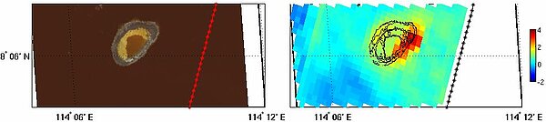
The Jason-1 and Jason-2 data were thus processed over a small reef, the Erika reef in the South China Sea. This reef, about 2 by 3 km in size, is very shallow (about 2 m depth) and its eastern side can emerged at low tide. Then the emerged area gives a very strong
signature in the altimeter data whilst at high tide the presence of the reef attenuates the waves and decreases the surface roughness.
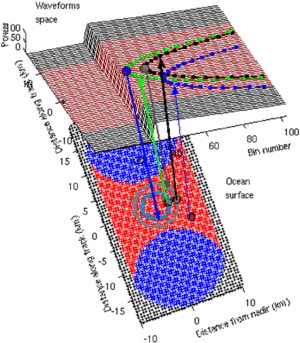
Imaging process of an altimeter. The lower surface represents the sea surface. Each element of the sea surface contributes to an ensemble of elements of the waveform space (upper surface). This ensemble is a parabola determined by the orbit characteristics of the satellite. Each element of the waveform space is the image of an ensemble of points of the sea surface. This ensemble is a disk at nadir and an annulus off-nadir. If we consider a group of waveform (e.g. the purple waveforms in the figure), it is the image of the ensemble of blue points of the sea surface. Within this ensemble, the red surface point are the one that contribute only to the purple waveforms. (see the animation, 3.4 MB) (Credits Ifremer)
See also:
- Image of the Month, January 2002: From Poseidon-1 to Poseidon-2
- Image of the Month, April 2006: Beacons in the waveforms
References:
- Tournadre J, B. Chapron and N. Reul, 2010: High resolution imaging of the ocean surface backscatter by inversion of Altimeter waveforms. Submitted to J. Atmos. Ocean. Tech.
News
 Archives .
- Aviso Newsletter .
- Search.
- Front-page news.
- Image of the month .
- 2026 .
- 2025 .
- 2024 .
- 2023 .
- 2022 .
- 2021 .
- 2020 .
- 2019 .
- 2018 .
- 2017 .
- 2016 .
- 2015 .
- 2014 .
- 2013 .
- 2012 .
- 2011 .
- 2010 .
- Dec. 2010: An island "seen" by altimeter.
- Nov. 2010: Mixing Argo and altimetry to estimate salt.
- Sep. 2010: ASAR vs altimetry South of Africa.
- Oct. 2010: Envisat measures up Antarctica.
- Aug. 2010: Altimetry helps search for a wreck.
- July 2010: North Atlantic Tides.
- June 2010: Penguins at large.
- May 2010: Finer currents.
- Apr. 2010: Drought and flood in the Amazon basin.
- Mar. 2010: Eddies in the Gulf of Alaska.
- Feb. 2010: Arctic sea ice shrinks and thins.
- Jan. 2010: Surface mirrors the deep.
- 2009 .
- 2008 .
- 2007 .
- 2006 .
- 2005 .
- 2004 .
- 2003 .
- 2002 .
- 2001 .
- 2000 .
- 1999 .
- 1998 .
- Operational news and status .