Mobile version

How is SLA distributed

Lively Data : June 28, 2006

For non-mesoscale studies such as climate analysis, the Live Access Server provide Sea Level Anomalies (SLA) at a lower resolution (1°x1°) in Near-Real Time. This dataset can be used to plot SLA distribution all around the globe.

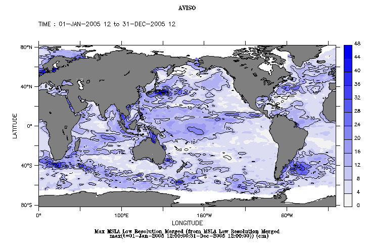
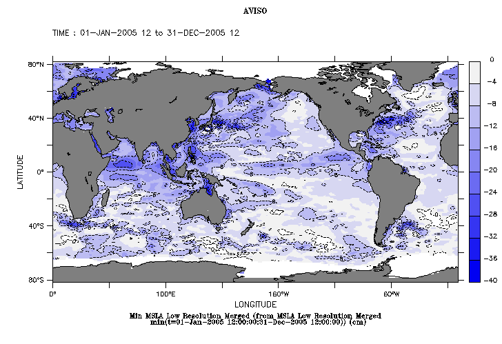
Left: Maximum Sea Level Anomaly during the year 2005. Right: Minimum Sea Level Anomaly during the year 2005.
Select Near-Real Time merged Maps of Sea Level Anomaly in low resolution, then click on "Define variable". Choose "maximum" (then "minimum") in "Select analysis type" menu, then the data period (from January 01, 2005 to December 31, 2005 here). To adjust your palette select the "Output options"; we choosed fill and contour levels as follows: (0,50,4) and (0,50,10) for Maximum maps; (-40,0,4) and (-40,0,8) for Minimum maps. Note that we selected the "inverse range of blues" palette in the first case and the "range of blues" palette in the second case, to highlight the extrema value in both situations.

In 2005 extrema values mirror the main ocean circulation structures (Antarctic Circumpolar Current, western boundary systems such as Kuroshio..), but such geographic distribution maps are especially of interest when compared with other main ocean surface parameters like salinity or temperature.
For example Levitus climatology data show that the most important temperatures on the globe are located around the Equatorial Indonesian-Pacific area, which also corresponds in our case to the maximum SLA. This area is often compared to a boiler for the Ocean/Atmosphere coupled system.


EnglishFrançais
Rss feedsContactPartnersFAQLexiconLegal noticePersonal Data Protection PolicyMobile
You must enable cookies in your browser preferences to save the modifications
You are using an older version of Internet Explorer, please update to take full advantage of Aviso+ features

Customize the home page

View all widgets
Reduce display
Public profile
User profile

Select/Deselect widgets

Discover AVISO+

Customizable home, reading tools, products search guide, etc.. Discover step by step the features of the new site AVISO+.

Customizable homepage

This home page is composed of blocks called "widgets".

Rearrange the blocks with a "Click & Drop".

Hide a widget with the cross at the top right. Reset or add a widget with the "wrench" icon. The "User" and "Public" profiles offer a predefined organization.

All the modifications are automatically saved as cookies on your machine so as to enable you to have your own specific AVISO+.

Reading tools

Ease your reading by choosing the page background colour (black/white) and/or by modifying the font size.

Browsing menu and breadcrum trail

To ease your browsing through AVISO+, you can use at any time the main banner items with the interactive submenus or use the browsing menu on the left side of the screen (it is open by default). For more readiness of the page contents, you can fold and unfold the browsing menu by clicking on the tab. At any time you can know where you are thanks to the browsing menu or the breadcrum at the top of the page.

Products search guide

The first submenu of the "Data" banner item leads you to a new search form enabling you to find quickier the product that suits your needs. The list of results is updated according to your selection criteria.

AVISO+ Multimedia

The first submenu of the "Multimedia" banner item leads you to AVISO+ collections of images and videos linked to altimetry and its applications. Have a nice visit!