Mobile version

How altimetry works

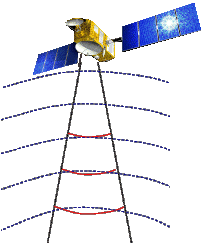
Altimetry satellites basically determine the distance from the satellite to a target surface by measuring the satellite-to-surface round-trip time of a radar pulse. However, this is not the only measurement made in the process, and a lot of other information can be extracted from altimetry.

The magnitude and shape of the echoes (or waveforms) also contain information about the characteristics of the surface which caused the reflection. The best results are obtained over the ocean, which is spatially homogeneous, and has a surface which conforms with known statistics. Surfaces which are not homogeneous, which contain discontinuities or significant slopes, such as some ice, rivers or land surfaces, make accurate interpretation more difficult.

  • Basic principle

    Radar altimeters permanently transmit signals to Earth, and receive the echo from the surface. The satellite orbit have to be accurately tracked (Doris system) and its position is determined relative to an arbitrary reference surface, an ellipsoid. The sea surface height (SSH), is the range from the sea surface to a reference ellipsoid.

  • Pulses and waveforms

    Altimetry satellites basically determine the distance from the satellite to a target surface by measuring the satellite-to-surface round-trip time of a radar pulse. The magnitude and shape of the echoes (or waveforms) also contain information about the characteristics of the surface which caused the reflection.

  • Frequencies used

    Several different frequencies are used for radar altimeters. Each frequency band has its advantages and disadvantages : sensitivity to atmospheric perturbations for Ku-band, better observation of ice, rain, coastal zones, land masses ... for Ka-band.


  • Delay Doppler / SAR altimetry

    The "SAR-altimetry" or "delay-Doppler altimetry" is a recent technique to process altimetry data.

  • Interferometers

    An altimeter/interferometer includes several altimeters mounted on masts which would acquire measurements simultaneously, thus providing continuous, single- or multi-altimeter wide-area coverage.

EnglishFrançais
Rss feedsContactPartnersFAQLexiconLegal noticePersonal Data Protection PolicyMobile
You must enable cookies in your browser preferences to save the modifications
You are using an older version of Internet Explorer, please update to take full advantage of Aviso+ features

Customize the home page

View all widgets
Reduce display
Public profile
User profile

Select/Deselect widgets

Discover AVISO+

Customizable home, reading tools, products search guide, etc.. Discover step by step the features of the new site AVISO+.

Customizable homepage

This home page is composed of blocks called "widgets".

Rearrange the blocks with a "Click & Drop".

Hide a widget with the cross at the top right. Reset or add a widget with the "wrench" icon. The "User" and "Public" profiles offer a predefined organization.

All the modifications are automatically saved as cookies on your machine so as to enable you to have your own specific AVISO+.

Reading tools

Ease your reading by choosing the page background colour (black/white) and/or by modifying the font size.

Browsing menu and breadcrum trail

To ease your browsing through AVISO+, you can use at any time the main banner items with the interactive submenus or use the browsing menu on the left side of the screen (it is open by default). For more readiness of the page contents, you can fold and unfold the browsing menu by clicking on the tab. At any time you can know where you are thanks to the browsing menu or the breadcrum at the top of the page.

Products search guide

The first submenu of the "Data" banner item leads you to a new search form enabling you to find quickier the product that suits your needs. The list of results is updated according to your selection criteria.

AVISO+ Multimedia

The first submenu of the "Multimedia" banner item leads you to AVISO+ collections of images and videos linked to altimetry and its applications. Have a nice visit!