


Latest News
01.06.2026 SWOT- guided sampling reveals distinct phytoplankton communities within a fine-scale front

A sampling strategy guided by SWOT across a fine-scale front in the North Balearic Sea during the BioSWOT-Med cruise revealed distinct phytoplankton communities within the front. A study published on Communication Earth and...
25.05.2026 Mapping the spatial structure of storm surges with Swot
 from Swot over Hurricane Milton in October 2024 (Credit: D. Vega-Giménez, Imedea)")
Swot can map the spatial structure of storm surges across diverse oceanic regimes[more]
13.05.2026 Swot reveals fine-scale eddies efficiency in modulating ocean interior turbulence
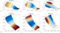
![Swot captures small structures previously elusive to nadir altimetry. (a) Swot vorticity derived from the SSH using the geostrophic assumption between 20 and 24 August 2023. (b) Gridded nadir altimetry geostrophic vorticity on 22 August 2023. Note the different color scales. from [Rolland et al. 2026].](/fileadmin/_processed_/0/9/csm_Rolland_etal_2026_Figure7-1140x557_4a7c4d075a.png "Swot and Gridded nadir vorticity from [Rolland et al. 2026].")
Swot reveals that fine-scale eddies are as efficient as larger and more energetic structures in modulating turbulence in the ocean interior[more]
04.05.2026 May 2026: Swot captured the vortex merger chronology in the Lofoten Basin
Swot observed an eddy-merging event in the Lofoten Basin. Such phenomena provide insights into ocean vertical mixing and heat transport.
23.04.2026 Swot effectively captures the presence of seiche-like structures in French Polynesia lagoons
An article published on the detection by Swot of seiche-like structures in French Polynesia lagoons[more]
20.04.2026 Swot reveals swells that connect ocean storms and mysterious seismic activity

A study published in the journal Nature Communications identifies a causal relationship between the occurrence of large storms in the Southern Ocean and, a few days later, bursts of microseisms with periods around 16 and 26 s,...
13.04.2026 New: High Resolution Coastal Sargassum Floating Algae Detection

The product "High Resolution Coastal Sargassum Floating Algae Detection with VENUS mission in Carribean Arc" provides Alternative Floating Algae Index (AFAI) coastal maps derived from VENµS multispectral imagery across five...
News
 Archives .
- Aviso Newsletter .
- Search.
- Front-page news.
- Image of the month .
- Operational news and status .