


Other geophysical applications
Geophysics is the study of the substances that make up the Earth and the physical processes occurring on, in and above it. Information derived from altimetry data can be used to study bathymetry, gravity anomalies or Tsunamis like detailed in the others items. However, altimetry also makes it possible to start on other geophysical applications : tectonic plate motions, poles motions, crustal motions, International Reference System, Earth's Centre of gravity... Doris, precise orbit determination and positioning onboard altimetry satellites, becomes a real space surveyor to develop geodesy and geophysics applications.
Doris sees the seasons weighing on the Earth  Mystery in Socorro  | 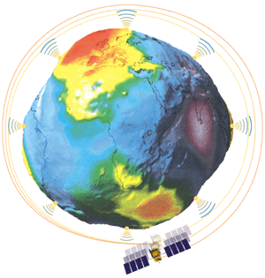 | Tracking the Earth's centre of gravity Earth's shifting poles  Contributing to the International Reference System |
Measuring continental drift
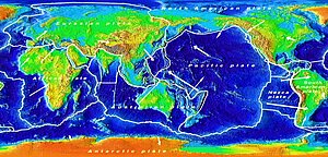
The Earth's crust is made up of slowly-shifting tectonic plates. The motion of these plates is what causes earthquakes. Precise measurements by Doris over several years have made it possible to track imperceptible horizontal displacements. Doris data have also allowed us for the first time to measure the rotation of the Antarctic Plate and to show that the African and Eurasian plates are moving two centimetres closer to each other every year.
Further information :
- Crétaux J.F., L. Soudarin, A. Cazenave, and F. Bouillé, 1998: Present-day plate tectonic plate motions and crustal deformations from the Doris Space system, J. Geophys. Res., 113, 30167-30181.
Doris sees the seasons weighing on the Earth
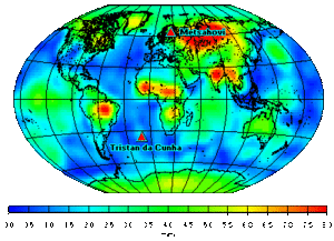
Pressures on the Earth's surface cause it to move it out of shape in much the same way as a ball does when pressed. Pressures are exerted by the weight of the atmosphere and by snow cover, soil moisture, ocean water masses, and other forces. The Doris precise orbit determination and positioning system detects the resulting small crustal motions of no more than a few millimeters. In particular, it enables us to observe seasonal variations, due for example to snow (Metsahovi) or ocean water masses (Tristan da Cunha).
Further information :
- Mangiarotti S., Cazenave A., Soudarin L., Cretaux JF., 2001. Annual vertical crustal motions predicted from surface mass redistribution and observed by space geodesy. J. Geophys. Res. Solid Earth 106 (B3): 4277-4291.
Mystery in Socorro ...
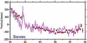
In early 1993, scientists observed an important and unusual subsidence (15 cm over the year) with the Doris station in Socorro Island, off Mexico. At the same time, the gauge sites immersed near here, recorded a rising sea-level. Combining these two data sets and those Topex/Poseidon, the explanation was found : the bottom sea had subsided following an underwater volcanic eruption.
Further information :
- Cazenave A., Dominh K., Soudarin L., Ponchaut F. and Le Provost C., 1999: Sea level changes from Topex-Poséidon altimetry and tide gauges, and vertical crustal motions from Doris, Geophys. Res. Lett., 26, 2077-2080.
Tracking the Earth's centre of gravity
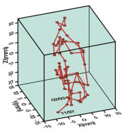
The Earth's centre of gravity is constantly changing its position within a three-centimetre cube in response to mass redistributions on the surface of the globe, caused by shifting masses within the ocean and by soil moisture, snow cover and groundwater. Doris measures these seasonal millimetric variations, which impact orbit calculations.
Further information:
- Bouille F., Cazenave A., Lemoine J.M., and Crétaux J.F., 2000: Geocenter motion measured from space geodesy and predicted from climatic data, Geophys. J. Int., 143, 71-82.
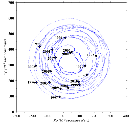
Earth's shifting poles
 |
|
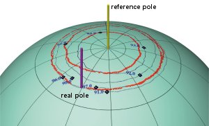
The Earth rotates in an irregular fashion due to mass shifts and variations in its rotational velocity. These variations cause its rotational axis, and therefore the poles, to "wobble". For example, observations have shown that the real position of the pole sometimes deviates up to ten meters from its theoretical position. This is the point about which the pole and the Earth's axis rotate.
Contributing to the International Reference System
The world's nations have been deploying grids of geodetic control points since the 18th century. In France, surveyors at the national mapping and survey agency IGN recently upgraded the country's geodetic network. The emergence of space geodesy techniques has helped to build a highly accurate global network called the International Terrestrial Reference Frame (ITRF). Since 1994, the network of Doris stations has been helping to maintain and densify the ITRF and to extend its coverage of the Southern Hemisphere.
Further information on Doris :
- Doris, the space surveyor.
- IDS, International Doris Service.
- <link en newsstand links external-link>List of related links on Doris
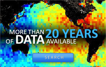
Applications
 Ocean .
- Coastal ocean applications .
- Ice and Cryosphere .
- Climate .
- Atmosphere, wind and waves .
- Geodesy and geophysics .
- Bathymetry.
- Geodesy.
- Other Geophysical applications.
- Tsunamis .
- Biology .
- Navigation by area .