


Delay-Doppler / SAR altimetry
The "SAR-altimetry" or "delay-Doppler altimetry" is a recent technique to process altimetry data. It was first operationally used for the CryoSat-2 mission, launched in 2010. In a nutshell, the technique uses the same concept as Synthetic Aperture Radar imagers by exploiting the Doppler effect caused by the satellite movement in the along-track direction. This provides a strong spatial resolution improvement in that direction, while across-track resolution remains the same than in conventional altimetry.
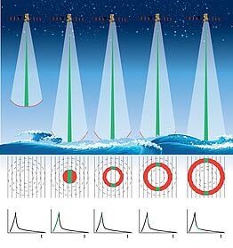
SAR-altimetry is for a large part a question of processing. Compared to conventional altimetry (or “LRM”: Low Resolution Mode) radar waves (or pulses) are emitted at a higher rate (~18 000 pulses per second instead of about 2000). This ensures that the phase of the signals remains relatively constant along consecutives pulses, a characteristic very useful in "unfocused" processing (see below). Since the satellite is in motion, ground reflectors backscatter the emitted signals at different frequencies depending on their along-track locations (i.e. in front, just below, or behind). This is the Doppler effect on which the SAR-altimetry rely. A Fast Fourier Transform applied to a pack (or burst) of consecutive reflected pulses (time dimension) discriminates the surface sampled on different Doppler strips on ground (frequency dimension). In practice, SAR altimetry unfocused processing is usually applied to bursts of 64 pulses. The radar wave footprint is thus split in 64 Doppler strips (or cells) about 300-meter wide in the along-track direction.
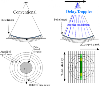
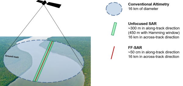
Conventional vs SAR altimetry ground footprint and resolution.(Credits CLS)
A given Doppler strip is seen in the radar footprint during 2.5 seconds approximately. Hence, a same Doppler strip on ground can be sampled at different satellite locations, depending on the burst frequency rate of the altimeter. The combination (or “stacking”) of different samplings of the same Doppler strip allows speckle noise reduction. This method is called the multi-looking processing. It improves the precision of the estimated geophysical parameters. For instance, the noise level on the Sea Surface Height estimated from Sentinel-3A (SAR altimetry) is 25% lower compared to Jason-3 (conventional altimetry).
Many potential improvements are possible with Delay Doppler/SAR mode altimeters over conventional altimeters for measurements over the oceans, coastal zones, ice surfaces and inland waters using processing (retrackers) adapted to the specific nature of Delay Doppler/SAR altimeter echoes.
The satellites concerned are currently (March 2019) Cryosat-2 and Sentinel-3 (A & B), and in the future Sentinel-3 (C & D) and Jason-CS/Sentinel-6.
Fully-focused SAR altimetry
The current SAR altimeters (Cryosat, the Sentinel-3A & B) were designed for unfocused SAR processing, where only "bursts" of radar pulses are coherently processed together, corresponding to a relatively short integration time (typically 3 ms). Even though not required in the current altimeters specification, the phase stability of the emitted radar pulses turns out to be maintained between the bursts.
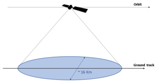
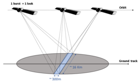
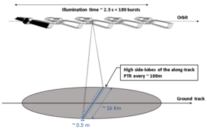
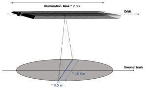
The Fully-focused SAR processing takes advantage of this to increase the SAR integration time (up to the entire illumination time of the surface, approximately 2.5 seconds), leading to a highly improved along-track resolution (up to 0.5 m vs. 300 m for unfocused SAR). The cross-track resolution remains unchanged since it is determined by the radar bandwidth (not by the processing).
As the integration time increases, the approximations on which the unfocused SAR processing is based become less and less valid. Therefore, more sophisticated and precise focusing algorithms, inherited from SAR imagery, must be used to achieve good accuracy.
With respect to unfocused SAR, the main asset of the Fully-focused SAR processing is the reduced footprint size. It allows both better noise reduction capability over ocean, and increased accuracy over inland water and sea-ice regions.
See Image of the Month, March 2019: Focusing on small water bodies
Fully-focused SAR altimetry: left, what is happening with Cryosat and Sentinel-3 (the altimeter emits 64 pulses four times, then stop, etc.); right Jason-CS/Sentinel-6 will emit/receive alternatively in an "interleaved" mode much more continuous. This will avoid measurements replicas.(Credits CLS)
References:
- Ejido A., Smith W., Fully Focused SAR Altimetry: Theory and Applications, IEEE Trans. Geosci. Remote Sens., vol 55, n°1, January 2017