Mobile version

Wetlands

Wetlands are ubiquitous on Earth, and provide with a number of "services" for life on Earth - including human beings' ones. Their observation is thus an important stake for all. 

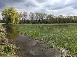
Strictly speaking, wetlands are wherever water meets land, including lakes and rivers, estuaries, deltas and coastal areas but also swamps and marshes, wet grasslands, peatlands, oases, floodplains and flooded forests, mangroves, man-made fish ponds, rice paddies and salt pans, etc. They are found everywhere around Earth, under every climate and altitude. Mostly, when talking wetland, though, rivers and lakes proper may not be the main topic, more swamps and marshes, or flooded areas. 


Wetlands'services

Wetlands provide a number of services, for everydays' life. They help in water resources control, disaster reduction, flood wave control, filter of pollutants, limiting wave erosion along shorelines. They are thus important for Economy, all the more since they also provide livelihoods for local indigenous people: fertile soils, fish, grazing (millions of people are concerned, one way or the other). 

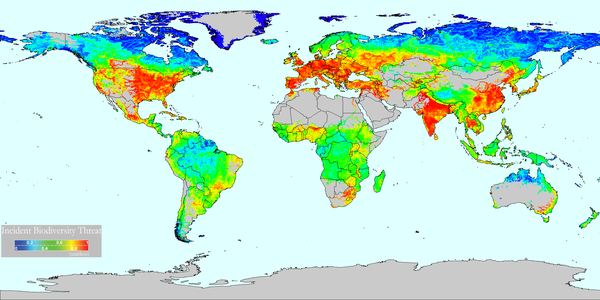
They are also support to remarkable level of biodiversity. The combination of shallow water, high levels of nutrients, and high primary productivity (the amount of biomass produced) is ideal for the development of organisms, so they are breeding grounds for birds, fish, shellfish and amphibians. Migratory birds frequently have stops in them. This can lead to ecotourism, and so Economy and people's livelihood.

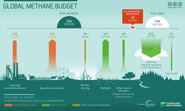
And, last but not least, wetlands have a huge impact on climate. They regulate carbon exchanges with the atmosphere via CO2 and CH4(carbon dioxide and methane) evasion. The Arctic wetlands, in particular, store enormous amounts of those greenhouse gases.

Observations & monitoring

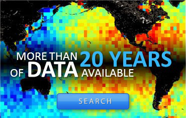
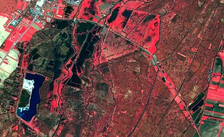
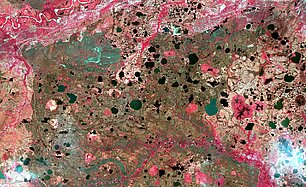
Observing wetlands depends on the size and latitude of them. Optical observation by satellite (eg with Sentinel-2) is one of the priviledged means of measuring their extent.

Altimetry is helping to better know what is controlling the flow, water paths, and the water exchange either between rivers or between river and wetlands. Swot will provide with both extent and height at high resolution all over Earth (up to 77° in Latitude North and South).

Wetlands'stakes

All this means that threats to wetlands have impact on those domains. And since they have been much disparaged as source of epidemics, lands wasted for agriculture, etc., they were often dried out in the past. Inland wetlands declined by 70-75% and coastal ones by 62-63% in the XXe century. The disappearance of a marsh will threatened biodiversity. Climate change is having also an effect on Arctic swamps, leading to methane emission. On the other side, small lakes and ponds are now built for flood control, and natural wetlands are more and more made nature preserves. 


References

C.J. Vorosmarty, P.B. McIntyre, M.O. Gessner, D. Dudgeon, A. Prusevich, P. Green, S. Glidden, S.E. Bunn, C.A. Sullivan, C. Reidy Liermann, and P.M. Davies,  Global threats to human water security and river biodiversity, Nature 467, 555-561 (30 September 2010) doi:10.1038/nature09440

On this topic:

  • Use of altimetry water level time series by MSF to help displaced communities in South Sudan

    Satellites such as the altimeters thus can help in warning of possible rise of the water level to help displaced communities in South Sudan

  • Higher resolution knowledge of flooded areas over the whole Earth

    Waiting for Swot, knowledge of wetlands and flooded areas can be computed from the wealth of satellite observation already available, combining them in all possible ways. It will provide with validation data when Swot will be launched

  • Groundwater from altimetry

    In the Amazon plain, the groundwater level is about the same than the rivers' and lakes', which can be measured by altimetry

  • Melting in the Kara Sea

    AltiKa data over the Kara Sea enable to distinguish there the effects of ice melting and also the presence of polylinias.

  • Ob bogs and wetlands

    Saral is giving very promising results, especially for wetlands and more generally inland waters. The measurements over the Ob basin area are providing with a mean to discriminate between water, ice and dry lands.

  • Missing: water

    Altimetry enable to monitor wetland surfaces in Siberia as well as river run-offs. Comparisons between those and precipitation lead to look for water missing to balance the water budget.

  • Altimetry in Mesopotamia

    Altimetry can be used to monitor the level of the numerous reservoirs and lakes, as well as the marshes of the Tigris-Euphrates basin.

EnglishFrançais
Rss feedsContactPartnersFAQLexiconLegal noticePersonal Data Protection PolicyMobile
You must enable cookies in your browser preferences to save the modifications
You are using an older version of Internet Explorer, please update to take full advantage of Aviso+ features

Customize the home page

View all widgets
Reduce display
Public profile
User profile

Select/Deselect widgets

Discover AVISO+

Customizable home, reading tools, products search guide, etc.. Discover step by step the features of the new site AVISO+.

Customizable homepage

This home page is composed of blocks called "widgets".

Rearrange the blocks with a "Click & Drop".

Hide a widget with the cross at the top right. Reset or add a widget with the "wrench" icon. The "User" and "Public" profiles offer a predefined organization.

All the modifications are automatically saved as cookies on your machine so as to enable you to have your own specific AVISO+.

Reading tools

Ease your reading by choosing the page background colour (black/white) and/or by modifying the font size.

Browsing menu and breadcrum trail

To ease your browsing through AVISO+, you can use at any time the main banner items with the interactive submenus or use the browsing menu on the left side of the screen (it is open by default). For more readiness of the page contents, you can fold and unfold the browsing menu by clicking on the tab. At any time you can know where you are thanks to the browsing menu or the breadcrum at the top of the page.

Products search guide

The first submenu of the "Data" banner item leads you to a new search form enabling you to find quickier the product that suits your needs. The list of results is updated according to your selection criteria.

AVISO+ Multimedia

The first submenu of the "Multimedia" banner item leads you to AVISO+ collections of images and videos linked to altimetry and its applications. Have a nice visit!