


Groundwater from altimetry!
Groundwater is a vital natural resource, even in a rainforest like the one over the Amazon region. Its variations have an important impact on wildlife and vegetation. However, especially in such an environment, in situ measurements are difficult and thus scarce.
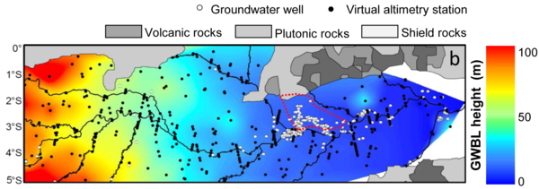
The Amazon plain ground, mostly made by alluvial deposit or other sediments tends to absorb water. During low-water periods, the groundwater sustains surface water bodies, so that the level of the groundwater is about the same than the rivers' and lakes'. This minimum annual level is defined as the base level of the groundwater table. So, by measuring the rivers and lakes'levels, the groundwater one can be estimated. Altimetry enable such a level measurement, at the points where the satellite ground tracks cross the water bodies ("virtual stations"). With a dense measurement mesh like Envisat's (or Saral now), a number of such points are defined, and a map of the groundwater base level is computed by interpolating between them over the 2003-2008 period. Annual variations (for the low water season) can also be mapped (see Image of the Month, April 2010: Drought and flood in the Amazon basin).
With now Saral, and in the future Swot, such studies can be continued, and also made over other regions. The long time series altimetry is now available to provide enable monitoring at a climatologic scale with continuous, intercalibrated and global datasets.
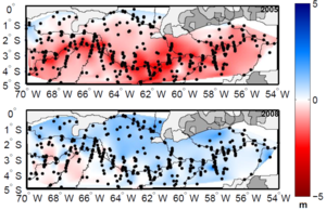
Groundwater base level variation by year computed using altimetry. Two extreme years are shown here , 2005 with an extreme drought, 2008 with a mild low-water season. (Modified after Pfeffer et al. [2014])
References:
- Hybam project (Geodynamical, hydrological and biogeochemical control of erosion/alteration and material transport in the Amazon basin)
- Pfeffer J., Seyler Frédérique, Bonnet Marie-Paule, Calmant Stéphane, Frappart F., Papa Fabrice, Paiva R. C. D., Satgé F., and Silva J. S. D. Low-water maps of the groundwater table in the central Amazon by satellite altimetry,Geophysical Research Letters , 41, 2014. doi:10.1002/2013GL059134