


River monitoring
For certain major rivers and wetlands, hydrological information can often be difficult to obtain due to a region's inaccessibility, the sparse distribution of gauge stations, or the slow dissemination of data. Satellite radar altimeters can potentially monitor height variations of inland waters. These heterogeneous surfaces require special processings.
The Amazon, the largest river system in the world, is in a part unknown because of its inaccessibility, especially upstream. If the river is not everywhere as wide as its mouth, flooded areas reflect radar altimeter correctly, which is sufficient to allow satellite altimetry monitoring.
River levels, temporary or permanent flooded areas (linked to the occurence of diseases like malaria in developing countries) can be observed and integrated into hydrological models.

Right, satellite image from Google Earth with Solimoes, Negro and Amazon rivers. Credits Legos
Years of measurements
The succession of altimetry missions since the early 90s allows a continuous monitoring of rivers. Thus, years of measurements are accumulated with Topex/Poseidon and Envisat, then Jason-2 & 3 and Saral, now with Sentinel-3 in areas where tracks of the satellites overlap or are not too far from each others.
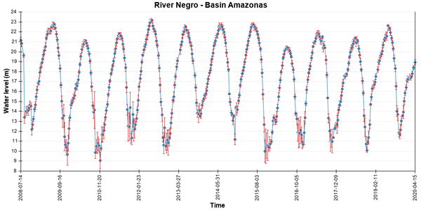
River level over the Solimoes and Negro rivers' confluence (giving birth to the Amazon). There are important annual amplitudes of the river and less accuracy in altimetry measurements during low water where the width of the river is not enough to "hook" the altimeter. Other examples are available e.g. for the following rivers: Orinoco, Congo, Indus, Niger, and Nile. Credits Legos / Hydroweb.
Further information :
- Hydroweb (Cnes/Legos, France).
- Bercher N., 2008. Précision de l'altimétrie satellitaire radar sur les cours d'eau : développement d'une méthode standard de quantification de la qualité des produits alti-hydrologiques et applications, Thesis AgroParisTech-Engref (pdf, in french).
- Mercier F. 2001: Altimétrie spatiale sur les eaux continentales : apport des missions T/P et ERS1&2 à l'étude des lacs, mers intérieures et bassins fluviaux. Thesis Université de Toulouse III (pdf, in french).