


Forecasting rivers
Altimetry enables to measure river levels at a given point, repeatedly in time. However, what is often more important to people is forecasting level with few days lead time, especially if flood is threatening and if the rivers are not measured by the same organization all along its stream, as it is usually the case when they crosse different countries. Combining Jason-2 Ganges-Brahmaputra levels with a forecasting model can lead to forecast water level 5 days in advance. A 20-day Jason-2 based forecasting of flooding during Aug 1, 2012 to Aug 20, 2012 was thus demonstrated in a real-time operational environment.
Especially, during the 2013 monsoon period, over 100 day, this forecast system has been tested in a more operational environment (see apps.geoportal.icimod.org/BDFloodforecasting and apps.iwmbd.com/satfor) and results from this test are currently evaluated. The Bangladesh Government is taking over the system from Monsoon 2015 season with a 2014 trial by their forecasting agency – Flood Forecasting and Warning Center (FFWC).
With the future SWOT mission, dedicated data, and especially a more complete coverage will enable such basin-wide monitoring and forecasting, thus helping to reduce the human costs of such flooding.
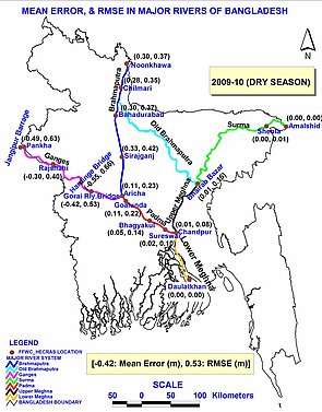
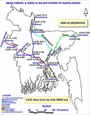
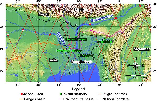
Accuracy of Jason-2-based 5-day forecast during dry season (left) and Monsoon season (right), in terms of mean error and RMSE of river level, given globally and at each of the 17 river stations (red circles) inside Bangladesh where the official forecasting agency of Bangladesh Government (Flood Forecasting and Warning Center-FFWC) issues forecasts. The major rivers shown here as solid and colored lines are modeled by the hydrodynamic river model HEC-RAS.
See also:
- Data: GDRs, IGDRs and OGDRs
- Applications: Lakes and enclosed seas
- Missions: Swot
Websites on this subject:
- Hydroweb
- Swot(Cnes)
- Swot (Nasa/JPL)
References:
- Hossain, F., Siddique-E-Akbor, A. H. M., Mazumdar, L. C., Shah Newaz, S. M., Biancamaria, S., Lee, H., Shum, C. K.. Proof of concept of an operational altimeter-based forecasting system for transboundary flow. IEEE Journal of Selected Topics in Applied Earth Observations and Remote Sensing. DOI: 10.1109/JSTARS.2013.2283402