


High-resolution hydrology: hydrology is changing dimension with Swot
Even though the first altimetry missions were designed for ocean, quite early on they were also used to look at rivers and lakes. Several projects offer today a database of river/lake level time series over some water bodies. However nadir altimetry can measure only just beneath the satellite, so an important number of water bodies are not, or not regularly sampled, because never overflown (e.g. Dead Sea, or Hourtin lake in France). Swot, by providing with an image everywhere thus enables to know where is the water, its slope and thus compute its discharge at least every 21 days. Comparisons between two successive measurements also provide with variations of those quantities.
Water cycle & Water storage changes
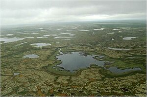
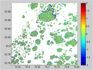
Floodplains and wetlands have an important impact on flood and ecosystem management. Moreover, lakes and reservoirs are of major importance including for issues related to water conflicts between nations. However, currently, there are huge uncertainties on their distribution. Swot, with its swath, should detect a large nomber of the water bodies. It should measure 65% of total annual lakes/reservoirs changes.
A global assessment of water resources, including transboundary rivers, lake and reservoir storage and river dynamics is of major importance to understand the global water cycle. This should also enable to define future Water Policy Strategies, based on the science of global water cycle and the evolution of freshwater resources.
Swot can refine, validate or change existing understanding based on its observational capability and may point to newer science-based strategies. It is able to improve and even provide first estimates (where unavailable) of human impact (e.g. dam building). Simultaneous availability of water height and width/extent from Swot should significantly improves physical models (hydrodynamic, land surface hydrology, climate).
Rivers and discharge
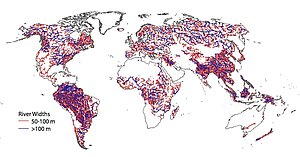
One of the major question in hydrology is the running waters. Today, very few rivers are observed and even fewer monitored. Swot will bring not only height measurements, but also slope and width of the rivers, and observe a lot more rivers than any combination of altimeter which has ever flown. Rivers over 100 m wide (goal: 50 m) should be measured with an accuracy of 10 cm over a 1 km2 area, 25 cm for a 250m*1 km area with a 1.7 cm/km slope (10 mrad) on an average length of 10 km .
By providing with those quantities regularly Swot enables to compute the rivers' discharge, and also help in modelizing rivers (and floods). Some studies are ongoing, in particular for complex cases like multi-braided rivers.
Estuaries
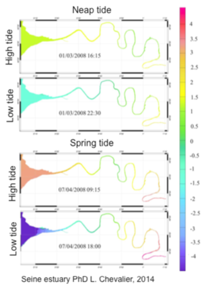
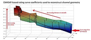
Estuaries serve as a meeting point between land and sea. Estuarine hydrodynamics are very complex because there are interactions between different water bodies: the sea with the same phenomena as the coast ocean (tides, waves, surges, sea level rise) but also the river, its tributaries, and groundwater. Numerical models have been increasingly used to predict river and estuarine flow, water quality and sediment and contaminant transport processes. However, to better define these models, and also to assimilate data into those models, one needs data, but only a few estuaries in the world have enough in situ gauges to allow this. The interest of using satellite height data for estuaries is to provide information on the hydrodynamic spatial variability. Until now, within estuaries, the contribution of satellites has mainly focused on the monitoring of water color and its relation to suspended sediment and chlorophyll. However, e.g. turbidity distribution varies considerably with tidal and river flow conditions, fluctuating on a variety of timescales, and are heavily influenced by bottom topography. In order to validate these models, we need the high resolution, 2D satellite altimetry data which Swot is bringing.