


Latest News
07.12.2021 Jason-1, the beginning of operational oceanography

Jason-1 was launched on December 7th, 2001, twenty years ago. It was the first follow-on to Topex/Poseidon, and the first of an operational series, renewed one year ago with Sentinel-6 Michael Freilich.[more]
06.12.2021 Mechanical tests begin on Swot
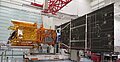
Swot is fully assembled and ready to begin mechanical tests on December 1st, 2021. The tests are conducted under the authority of Thales Alenia Space and the supervision of experts from Cnes, Nasa and JPL.[more]
25.11.2021 December 2021: FSLEs help to forecast oil spill dispersion
Oil spills are among the most damaging and frequent marine pollutions. Altimetry-computed FSLEs provide with an insight on the oil dispersion
22.11.2021 Sentinel-6 Michael Freilich: first year in orbit

One year ago, the successful launch of Sentinel-6 Michael Freilich marked a new stage in altimetry history, as well as a continuity.[more]
02.11.2021 November 2021: AI learning method to improve altimetry gridding
Improving altimetry data gridding to provide with the most accurate and most detailed datasets is among the ongoing studies, with Artificial Intelligence in particular
13.10.2021 Release of the extension of the ARCTIC OCEAN GRIDDED SEA LEVEL HEIGHTS

Monomission and multimission products have been extended until June 2020[more]
12.10.2021 AVISO+ releases updated Mean Sea Level (MSL) Ocean Indicator products

These climate key indicators are now based on the 2021 reprocessed L2P along-track AVISO+ products V03_00[more]
News
 Archives .
- Aviso Newsletter .
- Search.
- Front-page news.
- Image of the month .
- Operational news and status .