


Latest News
08.04.2026 Interaction of internal solitary waves and eddies observed for the first time with Swot
![ADT_swot with internal solitary waves detection for 22 August 2024 with an Anticyclonic eddy interaction ("AE", eddy marked by green contour) (from [Goret et al. , 2026])](/fileadmin/_processed_/c/5/csm_Fig_7_from_Goret_al_2026-copy_344f91a693.png "ADT_swot with internal solitary waves detection for 22 August 2024 with an Anticyclonic eddy interaction (\"AE\", eddy marked by green contour) (from [Goret et al. , 2026])")
For the first time, Swot enabled to observe Internal solitary waves signature in sea surface height. This allowed researchers to study the interactions of internal solitary waves with eddies on the Amazon Shelf, leading to a...[more]
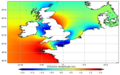
01.04.2026 April 2026: Sediment moves in the Ganges-Brahmaputra delta, measured by Swot
![Elevation change map of intertidal regions between 2024 and 2025 derived from Swot-based intertidal topography. (credit La Rochelle University, from [Yeasmin et al., 2026])](/fileadmin/_processed_/5/a/csm_202604_fig3_morphological_change_hp_43c6ee2672.png "Elevation change map of intertidal regions between 2024 and 2025 derived from Swot-based intertidal topography. (credit La Rochelle University, from [Yeasmin et al., 2026])")
Swot enables the measurement of changes in both the height and surface area of sediments in intertidal zones. This allows for the estimation of volume changes in these areas.
30.03.2026 Release of Native Grid FES 2022 tide model
This new product contains the FES2022b ocean tide elevation atlas on the Native Finite-Element grid of the model. One global file is available for downloading, and it contains the thirty-four tide components for FES2022 ocean...
25.03.2026 New v3.0 of Experimental Multimission Gridded Sea Level Heights and Velocities with SWOT using MIOST
A new version 3.0 of the Experimental Multimission Gridded Level 4 Sea Level Heights and Velocities with SWOT using MIOST mapping method is now available on AVISO.[more]
12.03.2026 Winds, waves and rain off the western European coasts seen by Swot and nadir altimeters
Two storms, Nils and Pedro, crossed South-west of France mid-February, coming from the Atlantic Ocean. As most such winter storms, they lead to high waves and high winds, but they also were heavy with rain.
02.03.2026 Mar. 2026: Microplastics distribution in the ocean influenced by eddies
 with the speed contour from the Eddy atlas on one given day seen also on SLAs (credit University of Las Palmas de Gran Canaria)")
Mesoscale eddies seem to act as dynamic reservoirs and transporters of microplastics in the ocean
04.02.2026 Explore the New AVISO CalVal Visualization Portal

Powered by OceanDataLab, AVISO introduces a new visualizer for exploring some of its key products.[more]
News
 Archives .
- Aviso Newsletter .
- Search.
- Front-page news.
- Image of the month .
- Operational news and status .