


Latest News
07.08.2018 23 July - 5 August 2018 weeks

2017, nouvelle année rouge pour le climat (Les Echos 02/08/2018)
Climat : 2017, année de tous les records (Le Monde 01/08/2018)
Les océans toujours aussi chauds, leur niveau toujours plus haut (BFM 02/08/2018)
Seuls 13% des...[more]
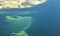
01.08.2018 August 2018: Waves steepen in accelerating currents
Altimetry showns an increased steepness of waves interacting with currents accelerating abruptly. High quality observations of waves and surface currents from modern altimeters and SAR, CFOSAT, SWOT and SKIM missions will help in...
30.07.2018 Visual presentation of the ODATIS Ocean Cluster
ODATIS, Ocean Data Information and Services, serves as the entry point to access all French Ocean observation data. Its general objective is to promote and facilitate the use of ocean observations sampled by way of in situ and...[more]
23.07.2018 9 - 22 July 2018 weeks

Why Our Intuition About Sea-Level Rise Is Wrong (Nautilus, 19/07/2018)
Expected sea-level rise following Antarctic ice shelves' collapse (Science Daily, 19/07/2018)
Reducing carbon emissions could limit sea level rise...[more]
12.07.2018 2 - 8 July week
Baltic Sea oxygen levels at '1,500-year low due to human activity' (The Guardian, 05/07/2018)
Red-hot planet: All-time heat records have been set all over the world during the past week (The Washington Post,...[more]
06.07.2018 July 2018: Adopting a Swot crossover for biophysical studies
Swot will be a major asset to study the socean fine scales, especially relevant for marine biology. Swot crossovers will be used for in situ campaigns.
03.07.2018 25 June - 1 July 2018 week

Comment les satellites Jason ont révolutionné notre connaissance du climat (Futura Sciences, 30/06/2018)
Politique américaine des océans : exit le climat (Science Presse, 29/06/2018)
The Sounds of Satellites (Earth...[more]
News
 Archives .
- Aviso Newsletter .
- Search.
- Front-page news.
- Image of the month .
- Operational news and status .