


Latest News
08.10.2024 Range latitudinal empirical correction for Jason-1/2/3 GDR

This dataset provides an abacus to correct from the effect of a rounding error in the ground processing of the Jason-1, Jason-2 and Jason-3 missions on the altimeter range estimations.
04.10.2024 Simulated Level-2 ODYSEA dataset

Level-2 ODYSEA-like simulated current observations are provided along with interpolated wind and current data from the MITgcm LLC2160-C1440 model.
25.09.2024 September 2024: Changing scale in eddy observation

The high resolution and wide swath of the SWOT's main instrument KaRIn enables the observation of eddies ten times smaller than previous altimetry missions
17.09.2024 SWOT Level-3 LR SSH v1.0.2 on AVISO
We are pleased to announce the release of the Basic and Expert SWOT L3_LR_SSH v1.0.2 (2-km) products on AVISO for both the Calibration (cycles 474 - 578) and Science (cycle 1 - ongoing) phases.[more]
06.08.2024 August 2024: Gibraltar's internal wave viewed by Swot
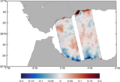
Internal waves can be generated when water is going through a Strait, such as Gibraltar. Swot is observing them.
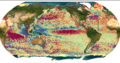
23.07.2024 Global view of seafloor gravity and bathymetry from one year of Swot
A team from Scripps Institution of Oceanography has processed 1 year of Swot KaRIn ocean level-2 data, enabling to retrieve bathymetric highs associated with, for example, ridges or seamounts of 1-km heights
11.07.2024 Antarctic Circumpolar Current - fronts : update

The product Antarctic Circumpolar Current - fronts has been extended to April 2023. It contains 3 files of variables to monitor the position of the three main fronts of the Antarctic Circumpolar Current (ACC) - the Polar Front,...
News
 Archives .
- Aviso Newsletter .
- Search.
- Front-page news.
- Image of the month .
- Operational news and status .