




News
Sentinel-6B fully compliant with mission’s requirements, & coherent with Sentinel-6Michael Freilich and Swot
Sentinel-6B vs Sentinel-6 Michael Freilich and Swot: all lights green for operations
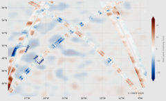
SLAs from S6B (LR NTC) compared with those from Swot, S6-Michael Freilich (LR NTC), and CMEMS L4 NRT (Duacs multimission processing) for 2026/05/24. All data show a strong agreement. Data Copernicus for S6 and L4, Cnes for Swot. Figure credit Cnes.
Sentinel-6B was launched, mid-November 2025, to be close enough to Sentinel-6MF to measure the same ocean features than its predecessor. This is standard procedure so as to check the whole system, detect and correct any bias if need be. Moreover, during this "commissioning phase", both redundant altimeters onboard were tested, as was the case during the Sentinel-6MF – Jason-3 similar phase.
All this done and analyzed, the differences between S6MF and S6B in range and sea level are at the millimeter level, with slight differences well within uncertainty level. Similarly, no significant geographical pattern differences are observed. All in all, the performances of the system are compliant with the requirements (see Summary of the "S6VT meeting" and discussion for a detailed synthesis).
Such cross-comparisons of two similar satellites, launched on the same orbit is a key to ensure the continuity of the Sea Level measurements, and thus the Mean Sea Level time series’ one. It has been done since the first such relay done between Topex/Poseidon and Jason-1 (although testing the redundant instruments onboard has been new for S6-Michael Freilich)
In addition to this tandem, Swot measurements were used as independent source of measurements, and the coherence is also there.uring the Ocean Surface Topography Science Team and Sentinel-6 Validation Team meetings late June, these results led to declare Sentinel-6B fit for operation and for taking over as reference mission. Sentinel-6MF will be shifted on an interleaved orbit, to complement its predecessors’ measurements for a few years.
- Data Access: L1B and L2 data are distributed by EUMETSAT on EUMETCast, the Data Store, and WIS2.0:
- The L1B and L2 datasets are described and also discoverable via the NASA's Earthdata portal.
Further information can be found at the links below:
-NASA's Earthdata: https://www.earthdata.nasa.gov/data/alerts-outages/sentinel-6b-altimetry-nrt-stc-datasets-release
-EUMETSAT: https://user.eumetsat.int/news-events/news/release-of-sentinel-6-b-altimetry-data
 Archives