


News
01.04.2011 07:15 Age: 15 yrs
Geoid model improved thanks to GOCE data
Category: News of the other missions
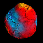
The Esa's Goce mission was launched two years ago and provides a Earth's geoid with unprecedented quality and resolution.
Credits ESA/HPF/DLR.
The Esa's Goce (Gravity field and steady-state Ocean Circulation Explorer) mission was launched two years ago and provides a Earth's geoid with unprecedented quality and resolution.
The geoid is defined like an equipotential surface. On oceans, the geoid coincides with the mean sea surface, i.e. with a calm ocean surface without tides and currents. It's a reference to measure ocean circulation, sea-level change and ice dynamics.
The precise model of Earth's geoid made by Goce helps to improve our understanding of the ocean dynamic.
Further information:
- Esa's website: <link http: www.esa.int esacp sem1ak6uplg_index_0.html _blank external-link-new-window>Earth's gravity revealed in unprecedented detail
- Applications: <link internal-link>Geodesy


