


The Aral Sea
written jointly with Jean-François Crétaux, Legos
The level of the Aral Sea has been dropping so much since the 1960s, due to the large volume of water diverted upstream for irrigating crops, that the shorelines have shrunk by more than 74 miles (120 km) in some areas and the Aral Sea has now split up into four basins. While they are still linked to each other, the four basins might become totally independent of each other if the level drops even further.
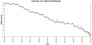
The catastrophic drop in the level of the Aral Sea is continuing. Due to intensive tapping for irrigation upstream of its tributaries, this slightly saline lake has lost a great part of its volume and surface area since 1960 (shrinking from about 27,027 square miles (70,000 km²) in the 1960s to 7,722 square miles (20,000 km²) at the beginning of the 21st-century).
This is however not the first time that the Aral Sea has dried up. This had already occurred at the beginning of our era and especially during the middle ages (in the latter case probably also due to irrigation). Nevertheless, the ecological situation and especially the public health situation are a source of great concern in the region in which the population is suffering from respiratory illnesses due to sand, to deposits of salts and pesticides left by the sea as it dries up and which are carried by winds over great distances.
In 1989 the sea divided into two basins. The Large South Aral Sea and the Small North Aral Sea. Since 2005, the Large South Aral Sea began to divide into sub-basins, forming the south-east Aral and the south-west Aral divided by the Kulandy strait, between 0.62 and 1.86 miles wide(between 1 and 3 km). To the north can be seen the sub-basins of the Small Aral Sea, one blocked by a dike at the entrance to Berg strait and, the other, to the south of the Kokaral peninsular at Tchebas bay.
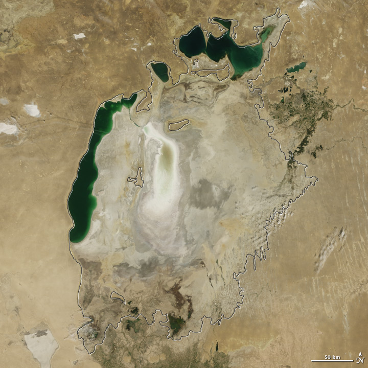
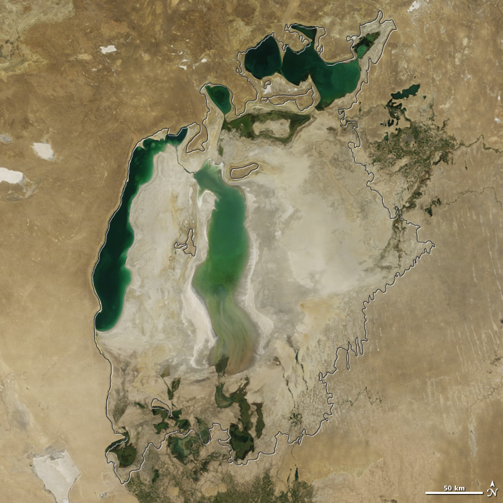
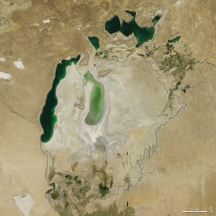
Satellite images of the Aral Sea taken in 2009 (on the left), in 2010 (in the middle) and in 2011 (on the right, Modis Image, Nasa). The outline in black shows the limits of the Aral Sea in 1960.
Altimetry observation
Since 1992 radar altimetry has been used to monitor the evolution of the level of these two "seas" very accurately as has been confirmed by some in situ data and studies of the water cycle budget.
The precision of the altimetry measurements is not however homogeneous, neither for this whole period nor for the whole zone: when the sea withdraws, the segments of the satellite ground tracks become smaller, as the radar echoes are more or less well reflected by the ground; since the topography of the smaller North Aral Sea is more isolated, the footprint of the radar beam targets heterogeneous surfaces and the return signal is perturbed by noise.
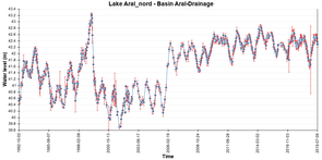
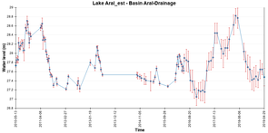
The basins of the North Aral Sea
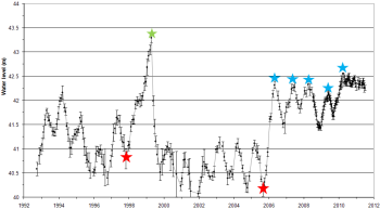
The two sub-basins in the North (the Small Aral Sea in the North and the Tchebas basin) are from 3.28 to 23 feet (from 3 to 7m ) above the level of the southern basins. The significant fluctuations in level are irregular and correspond in fact to attempts to build a dike between the two seas in order to keep the Syr Darya waters in the northern basin. One of the dikes built between the two seas raised the level of the Small Aral Sea by 3.28 feet ( 3 m) and increased its surface area from 1544 to 2316 square miles (4000 to 6000 km²). However in April 1999, accumulated water pressure destroyed the new dike, which explains the significantly low level recorded in that year.
|
Variations in water level of the small North Aral Sea measured using altimetry data (multi-satellite data collected between 1993 and 2003; Envisat (tracker ice1) from 2003 to June 2008; Jason-2 (tracker ice1) as of June 2008). The red stars show the date of construction of the two dikes; the green star marks the destruction of the first dike; the blue stars mark the release of "artificial" water by the dam gates. Graph by Legos.
In August 2005, the construction of a concrete dike in the Berg strait made it possible to again regulate the level of the North Aral Sea: after a sudden increase in level of about 6.74 feet (2 m) in a few weeks, the dam gates were opened to release the surplus spring-melt water carried by the Syr Darya River, thus maintaining the mean level of the North Aral Sea at about 141 feet (42 m).
This release of water evacuated a few cubic kilometres of water per year to the south via the Berg strait, thus maintaining a very saline, small lake, previously the Tchebas Bay. A small amount of water (difficult to estimate) also supplied the South Aral Sea, without however being able to stop the level dropping.
During 2010, the level of the North Aral Sea also rose more than in previous years (during which there was a systematic surplus due to the spring floods of the Syr Darya River being drained by opening the dike gates), to an average of 143 feet instead of its normal 141 feet (42.5 m instead of 42 m).
The opening of the gates in 2010 also made it possible to supply a greater volume of water via the Berg strait towards the south, which also no doubt helped raise the level of Tchebas lake and the basins of the south-east and south-west Aral.
Furthermore, an article was published on 20 August 2011 in a Kazakhstan daily newspaper about the decision of the Kazakh government to finance the construction of a new dike for the North Aral basin, in order to create a 25 x 9 miles (40 x 15 km) reservoir in the northern part of the space. The level of this new reservoir would be 168.5 feet (50 m) above that of the sea (currently 143 feet (42.5 m) for the Northern Aral), with a depth of about 33.7 feet (10 m) and a volume of 1.2 cubic miles (5 km³). It would be supplied by a canal coming from Syr Darya and would enable the city of Aralsk, which had previously been a major fishing port when the Aral Sea was at its maximum level in the 1960s, to again become a port with a new fishing fleet. This project costing millions of dollars will be partly financed by the Kazakh government and partly by the World Bank, as was the case in 2005 for the dike on Berg strait.
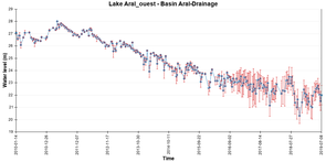
The south-east Aral and south-west Aral basins
Until 2010, satellite imagery, among others, revealed a very significant decrease in the surface area of the south-east Aral basin due to its very slight depth, whereas the south-west Aral basin, which is deeper, did not reveal a major variation in its surface area. On the other hand, in terms of variation in level, there was a significant decrease in the level of both sub basins by a rate of approximately 127 to 203 inches per year (50 to 80 cm).
As far as the hydrological budget is concerned in this very arid region, the contribution of rainfall is slight (of the order of 3.94 to 5.91 inches (10 to 15 cm) per year) whereas evaporation is much higher (of the order of 3.28 to 3.94 feet (1 to 1.2 m)). The only contributor which could stop the South Aral basin from drying up would be surface run-off from Amu Darya whose delta is located in the south-east part of this basin, but this is not possible since too much water is tapped for irrigation in Uzbekistan.
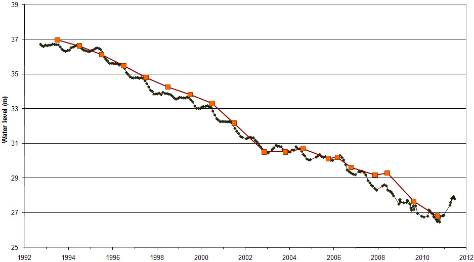
Only excess rainfall would enable a nevertheless very temporary respite. This is what happened in 2010 with a level which had not been reached for at least 20 years, since, as can be seen in the time series of the level of the South Aral Sea (in fact it is of the south-east Aral basin for the last two years), the level rose by about 4.6 feet (1.4 m) in 2010. The flooded surface area of the south-east Aral doubled (from 926 to 1891 square miles (2400 to 4900 km²)) and the volume was increased fourfold (from 0.42 to about 1.7 cubic miles (1.75 to about 7 km³)).
In situ measurements of the flow of the Amu Dary entering the delta (taken at the Kyzldjar station, display the time series here) have confirmed this phenomenon which occurred in 2010 and explain it very well. The same phenomenon was revealed by altimeters measuring several other major lakes in central Asia (Balkhash, Zaisan, Sassykol, Issykul, Kapchagayskoye).
Other years with as much rainfall (1998 for instance) did not reproduce this phenomenon since at that time, the evaporation predominated. The surface area of the South Aral Sea was then about three times bigger (9650 square miles as compared with 3281 square miles (25,000 km² as compared with 8500 km² in 2010)) and consequently the evaporation was three times as great. In 2005, since the surface area of the Aral had again decreased, the particularly strong floods in that year were also able to prevent the South Aral basins from drying out but without however reversing the trend.
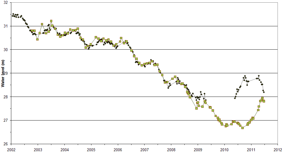
From 2009 on, since the level of the south-east Aral Sea had previously dropped so much, the ground tracks of the Jason-2 and Envisat satellites no longer covered the flooded area; consequently the altimetry measurements were not as capable of showing the level. At the beginning of 2010, the measurements were again able to show the level, following the flooding of the Amu Darya, which in this area had greatly increased; whereas for the south-west Aral, this rise in level occurred later. It probably took some time for the flood arriving from the south-east of the basin via the Amu Darya delta, and which was recorded by altimeters fairly early in this flood episode, to propagate gradually to the North and thus supply the south-west Aral basin whose level also increased strongly around the summer of 2010.
At the beginning of 2011, the south-east Aral was entirely frozen (personal communication from Peter Zavialov, a Russian researcher at the oceanographic Institute in Moscow), which was not the case for the south-west Aral and which might explain the "gap" in the altimetry measurements at the beginning of 2011 for the south-east Aral. During the spring of 2011, the south-east Aral began to dry out but, for the first time since this basin had been observed by satellite altimetry, this was not the case for the south-west Aral, or at least it occurred much later (in June). It is possible that the drop in the level of the south-east Aral was due to an adjustment between the two basins via the Kulandy strait. The last altimetry measurements taken in June 2011 showed that the levels of the two basins were fairly similar. A time lapse was also observed for the conveying of water between the Amu Daria delta and part of the south-east Aral basin, which are now about 62 miles (100 km) apart.
The filling or draining of the south-east and south-west Aral Sud basins is no longer instantaneous: we are witnessing the gradual separation of the South Aral into two basins which, if the level continues to drop, will become independent of each other.
Updated level heights for the different Aral Sea Components: first row, Aral South (left) and North (right); second row the two components of the South Aral, West and East (Credits Hydroweb)
Further information:
- Altimetry applications in videos: Aral Sea
- Animations with Modis images (on Nasa's Terra satellite) between 2000 and 2018.
- CAWa project (Cental Asian Water): Analysis of water-related situation in Syr Darya and Amu Darya river basins.
Aral Sea references
- Crétaux J-F, S. Calmant, R. Abarca Del Rio, A. Kouraev, M. Bergé-Nguyen and P. Maisongrande, Lakes studies from satellite altimetry, Handbook on Coastal altimetry, Springer ed., chap. 19, pp 509-534, 2011
- Crétaux J-F., R. Letolle, A.V. Kouraev, Aral Sea level variability, Handbook of environmental chemistry, Vol 7 Water pollution, Ed A.G. Kostianoy, A.N. Kosarev,Springer Ed, pp 181-194, 2010
- Kouraev A.and J-F Crétaux, Aral Sea Ice conditions from historical and satellite observations, Handbook of environmental chemistry, Vol 7 Water pollution, Ed A.G. Kostianoy, A.N. Kosarev, Springer Ed, pp 195-218, 2010
- Crétaux J-F, R. Letolle, and S. Calmant, Investigations on Aral Sea regressions from Mirabilite deposits and remote sensing, Aquatic Geochemistry, doi: 10.1007/s10498-008-9051-2, 2009
- Kouraev AV, Kostianoy AG, Lebedev SA (2009) Recent changes of sea level and ice cover in the Aral Sea derived from satellite data (1992-2006). - J. Mar. Systems, V.76, N 3: 272-286. doi:10.1016/j.jmarsys.2008.03.016.
- Calmant S., Seyler F. and Crétaux J.F., Monitoring Continental Surface Waters by Satellite Altimetry, Survey in Geophysics, special issue on Hydrology from Space, Vol 29, Issue 4-5, pp 247-269, 2008.
- Aladin N., P. Micklin, D. Keyser, I. Plotnikov, R. Letolle, A. Smurov, and J-F. Crétaux, Results of Aral Sea studies, Int Assoc. of Theorical and Applied Limnology, Vo; 29, pt 5, pp 2271-2275, 2006
- Crétaux J-F and C. Birkett, lake studies from satellite altimetry, C R Geoscience, doi: 10.1016/J.cre.2006.08.002, 2006
- Crétaux J-F, Kouraev A.V., Papa F., Bergé Nguyen M., Cazenave A., Aladin N.V., and Plotnikov I.S., Water balance of the Big Aral sea from satellite remote sensing and in situ observations, Journal of Great Lakes Research, 31 (4), 2005.
- Aladin N.V., Crétaux J-F., Plotnikov I.S., Kouraev A.V., Smurov A.O., Cazenave A., Egorov A.N., Papa F., Modern hydro-biological state of the Small Aral Sea, Environmetric, Vol 16, Issue 4, pp 375-392, June 2005.