


Lake Chad
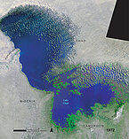
Lake Chad, once one of the largest on Earth has been decreasing since the sixties. Today, it only covers about one-tenth of its maximum surface. However, Topex/Poseidon is observing an increase. Lake Chad's large surface in a topographical setting with low relief makes it an excellent object for study using altimetry satellites. This technique, originally developed for measuring sea-levels from Space in the early 1990s, can be easily adapted for a study of the variations to the level of such lakes.

Lake Chad lies in a slight depression in the arid Sahel region at the heart of the African continent, seeming like a vast freshwater oasis supporting a rich variety of ecosystems. Surrounded by four countries (Chad, Niger, Nigeria and Cameroon) and depending for its water on the great rivers that feed it (the Chari for 85% and also the Komadugu-Yobe), it is important in both economic and geopolitical terms.
The highly variable rainfall in the region has a direct and considerable influence on the lake's natural fluctuations. The severe Sahelian drought of the 1970s and '80s marked the beginning of a period of surface shrinkage. This was not the first such event, as historically Lake Chad has oscillated between a 'Mega-Lake' Chad (6,000 years ago and again in the 11th and 12th Centuries) when it covered up to 340,000 km² and a 'Little Chad' of 1,500 to 14,000 km² at the beginning of the 20th Century and again since 1973.
Lake Chad also has wide seasonal fluctuations that depend mostly on its main tributary, the Chari, a river barely 1,000 km long that rises in a sub-humid region of the Central African Republic. The May-June rainy season, upstream from the drainage area, determines how the lake will fill between October and January. The dry season causes considerable evaporation (95% of the losses in the lake's water budget) with the lake finding its lowest level in July-August. Even the lake's natural rhythms are therefore unreliable and, because it is relatively shallow, a difference of a few tens of centimetres of accumulated rainfall can cause several tens of thousands of hectares to be covered or uncovered. In drought conditions, the lake may divide into two or three smaller parts: the northern basin is the first to have its salinity rise before drying up completely, while the southern basin, with a less arid climate and fed directly by the Chari River, suffers slighter fluctuations. The marshy or dried-up parts become covered with vegetation, or are fertilised with alluvia.
This situation has contrasting effects on the local economy. The population living around the lake are of many different origins, some as 'climate refugees' from the encroaching Sahara. The lake's shrinkage is harmful to fishing (reduction in fish resources, changes to the balance of species, boats becoming entangled in the vegetation) but beneficial to the development of crops and grazing on the rich alluvial soil. It is hard to quantify the quantities of water removed across the drainage basin by these new agricultural practices. Irrigation and damming the rivers do not seem to have any great impact on the lake's water budget, except during droughts. A major (and controversial) project is being studied with a view to stabilising the fluctuations of Lake Chad in the future: a long artificial canal to feed water into the lake from the Oubangui, a river in the Congo basin.

Further information:
- Applications: Lakes and enclosed seas monitoring
- Altimetry applications in videos: Lake Chad
- Mercier F., 2001: Altimétrie spatiale sur les eaux continentales : apport des missions Topex/Poséidon et ERS-1&2 à l'étude des lacs, mers intérieures et bassins fluviaux. Ed. CLS. PhD Thesis, University Paul Sabatier (Toulouse III, France), 243pp.
- Magrin G., 2007 : Le lac Tchad n'est pas la mer d'Aral. Mouvements.(in French)
- Hydroweb (Legos): Lake Chad time series.