


Forecasts which are increasingly more reliable
Ocean tides represent more than 80% of ocean variability. Sea level variations and consecutive currents near the coast are complicated processes; modelling pelagic and coastal tides leads to a better knowledge of this phenomena.

Breaking down tides to calculate them better
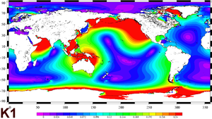
In order to calculate tides, they have to be broken down into sinusoidal waves of given periods, each of which represents one component of the problem. Thus, one of the waves, called M2, is due to the attraction of an 'ideal' Moon placed on a perfectly circular orbit in the Earth's equatorial plane. It has two high and two low tides per day (semi-diurnal wave). The K1 wave, with a diurnal period, reflects variations in declination of the Moon and Sun. The amplitude of the tide at a given moment and given place is the sum of all these sinusoidal waves. In certain areas, a hundred of these waves have to be added to obtain a precise forecast.
Amplitude in meters of two main tide components from FES2004 model, one semi-diurnal (top, wave M2), the other diurnal (down, wave K1). While M2 is clearly dominant on the French coasts (two tides per day) K1 is dominant in the China Sea where there is only one tide per day. (Credits CLS /Legos).
Models enriched with observations
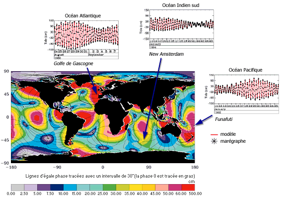
Tide models are based on physical laws. Their precision can be improved by integrating observation data. Tide gauges installed just off the coast provide precise, local measurements. Altimetry satellites such as Topex/Poseidon, ERS, Envisat or Jason-1, cover the whole Earth, particularly in the middle of the sea, at regular intervals. Using mathematical procedures, this complementary information can be integrated into tide models. In addition, tides have to be filtered out of altimetry data in order to determine other ocean variations (currents, eddies, seasonal variations, etc.).
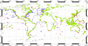
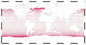
Tide gauges's location around the globe (IHO databases, Woce, Iapso), and Topex / Poseidon crossover points (cycle 126). We see that tide gauges are mainly located on the coast, where they continuously measure sea level variations, sometimes for a century. The Topex / Poseidon measurements are regularly spread over the ocean, but with measurements every 10 days.