


Jason-3 GDR 2016 validation
By succeeding TOPEX/Poseidon, Jason-1 and Jason-2, Jason-3 has extended the high-precision ocean altimetry data record (https://www.aviso.altimetry.fr/?id=601&L=0). It was launched on January 17 2016 and during the tandem phase with Jason-2 (February 12th to October 2nd 2016) both satellites were on the same ground-track (with only 80 seconds delay), which is a unique opportunity to precisely assess parameter discrepancies between both missions and detect geographically correlated biases, jumps or drifts. During 2016, focus is done on the results during this tandem phase, thus from cycle 0 to cycle 23.
OGDR and IGDR products have been publicly available since June 30th 2016. OGDRs were generated in version “T” until cycle 18/pass 137, and then turned into “D” version. Concerning IGDRs, they turned from “T” to “D” version at cycle 14/pass 143 on June 27th. GDR products have been available in version “T” on ftp://ftp.jason3.oceanobs.com or via www.class.noaa.gov since early October 2016 (more details on products versions on Jason-3 handbook).
During each cycle, missing measurements were monitored, spurious data were edited and relevant parameters derived from instrumental measurements and geophysical corrections were analysed for OGDR, IGDR and GDR. More information is available in the Jason-3 annual validation report.
Focus on tandem flight: cycle 0 to cycle 23
Looking at data availability over the 23 first Jason-3 cycles period (see Figure 1), Jason-2 presents 96.5% (99.5% over ocean) of available measurements whereas Jason-3 has 97.6% (99.0% over ocean) of available data. Due to some events, measurements are missing: Jason-2 had 9.66% of missing measurements during cycle 285 (cycle 5) due to a GPS upload and an AMR anomaly. Concerning Jason-3 there is 21.02% of missing measurements due to the GPS platform software upload during cycle 3, and cycle 0 is only half a cycle. However, specific events or big anomalies aside, the available Jason-3 measurements are close to 99.97%. During this tandem phase, the behaviour of Jason-3 over ocean was excellent and in line with Jason-2 on the same ground track.
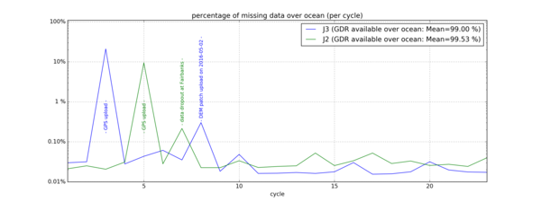
Figure 1: Data Availability of Jason-3 and Jason-2 GDRs
Sea level anomalies
Jason-2 and Jason-3 SLA show similar behaviours (see Figure2). The mean bias between missions, estimated here using GDR data over repeat-track analysis is 2.98 cm and is very stable.
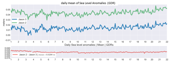
Figure 2: Jason-2 (green) and Jason-3 (blue): Sea Level Anomalies with GDR product version
(note that the data unavailability during cycle 3 (March 15th to March 17th) is due to GPS upload)
However, using IGDR data (Figure 3), daily mean SLA was drifting due to the radiometer instrument (Figure 3, red curve). It was corrected in GDR (see Figure 2) thanks to the NASA/JPL ARCS system. The radiometer drift in IGDRs products is also evidenced in Figure 4 that displays the mean difference compared to wet tropospheric correction from the ECMWF model.
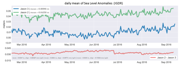
Figure 3: Jason-2 and Jason-3 Sea Level Anomalies with IGDR product version
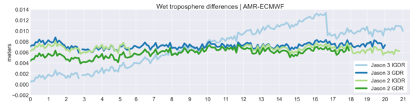
Figure 4: Radiometer minus ECMWF model wet troposphere correction for Jason-2 and Jason-3 over tandem phase
Performances at crossover points
The mean of SSH difference at crossovers for Jason-3 and Jason-2 are equivalent (respectively -0.12 cm vs -0.13 cm, see Figure 5). However, Jason-3 crossover SSH presents higher variations than Jason-2. Investigations are currently in progress to further understand such a behavior.Concerning the SSH standard deviation at crossover points (Figure 6), both missions show very good and stable performances: 5.03 cm for Jason-3, 4.93cm for Jason-2.
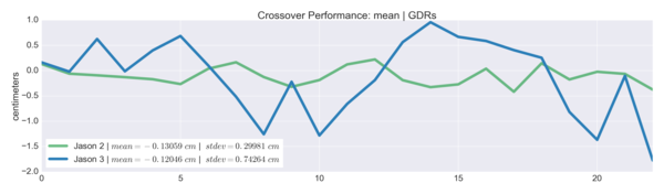
Figure 5: mean of SSH differences at crossovers
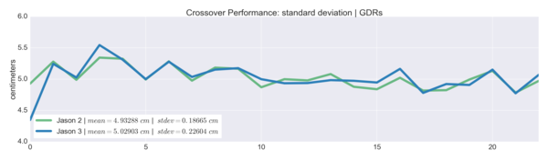
Figure 6: standard deviation of SSH differences at crossovers
Contribution to global mean sea level
Since 2016, Jason-3 has been the reference altimetry mission to estimate the Global Mean Sea Level (GMSL), instead of Jason-2. Regional and global biases between missions have to be precisely estimated in order to ensure the quality of the reference GMSL serie. For more precisions, see the dedicated section here.