


VENUS Level-2 Marine reflectances
Type of dataset: VENµS Level-2 Marine reflectances
Digital Object Identifiers (DOIs):
- VENµS Level-2 Marine reflectances: 10.24400/527896/a01-2024.015 - more metadata
Condition of access: CC-BY-NC (Creative Commons - Attribution, No commercial usage)
Use: Ocean Color Remote Sensing ; Marine Ecosystem Monitoring ; Coastal Water Monitoring
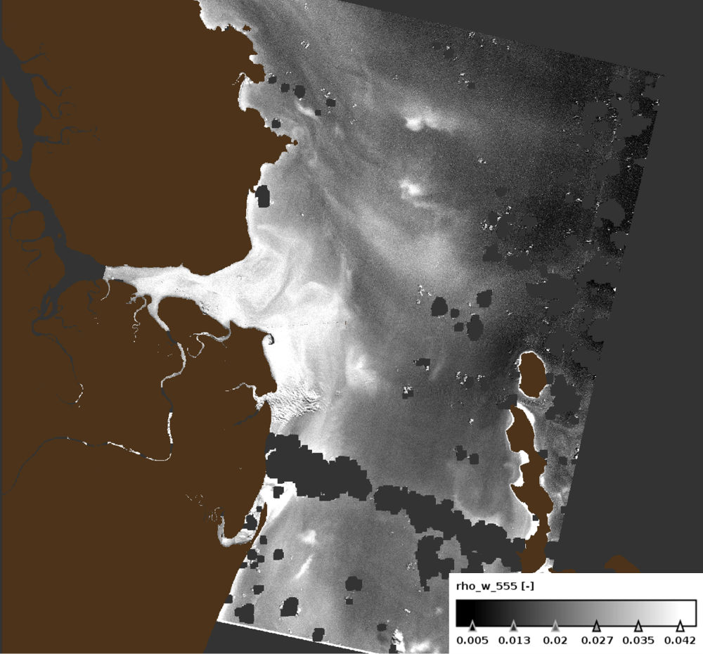
Description: This Level 2 product provides marine reflectances from the VENµS mission, processed with the Polymer algorithm, on a subset of sites with coastal or inland areas.
VENµS (Vegetation and Environment monitoring on a New Micro-Satellite) is a Franco-Israeli satellite launched in 2017, dedicated to the fine and regular monitoring of terrestrial vegetation, in particular cultivated areas, forests, protected natural areas, etc. The images acquired in 12 spectral bands by a camera provided by CNES, on a selection of about one hundred scientific sites spread over the planet, are of high spatial (5 m) and temporal resolution. The lifetime of the VENµS satellite has been divided into two phases: a first phase VM1 at an altitude of 720 km with a 2-day revisit, a native spatial resolution of 5.3 m and a swath of 27.6 km from August 2017 to November 2020, and a second phase VM5 at an altitude of 560 km with a daily revisit, a native spatial resolution of 4.1 m and a swath of 21.3 km from March 2022 to July 2024.
VENµS is the first sensor on board an orbiting satellite to combine such revisit frequency and spatial finesse for vegetation monitoring.
A subset of sites with coastal areas or inland waters have been identified to generate Level 2 data dedicated to marine reflectance. The geographical areas covered are given through a kmz file, see below to download it.
This Level 2 data product has been processed using the Polymer algorithm developed by Hygeos (https://hygeos.com/en/polymer/) and provides marine reflectances for the VENµS bands from 420 to 865 nm. These reflectances, without units, include a bidirectional normalization for the Sun at nadir and the observer at nadir.
VENµS data products (Level-1, Level-2 and Level-3) are primarily generated with the MAJA algorithm, further information can be found on THEIA website: www.theia-land.fr/en/product/venus/
Geographic coverage: Latitude -65.00 to 85.00, Longitude -180.00 to 180.00
Citation: The VENµS Level-2 marine reflectances product, produced by CNES and Hygeos as part of the VENµS project (CNES, ISA) is made freely available by AVISO". CNES, 2024. VENµS Level-2 Marine Reflectances (v1.0) [Data set]. CNES. https://doi.org/10.24400/527896/A01-2024.015
Resources:
- VENµS Level-2 marine reflectances User Handbook
- Further information on THEIA, Venµs Surface Reflectance: https://www.theia-land.fr/en/product/venus/
- Further information on THEIA, Reflectance Venµs Level-2A: https://www.theia-land.fr/ces-imagerie-radiometrie/imagerie-optique-hr/
- GEODES website: https://geodes.cnes.fr/
- Dick, A., Raynaud, J.-L., Rolland, A., Pelou, S., Coustance, S., Dedieu, G., Hagolle, O., Burochin, J.-P., Binet, R., Moreau, A., 2022. VENμS: Mission Characteristics, Final Evaluation of the First Phase and Data Production. Remote Sensing 14, 3281.: https://doi.org/10.3390/rs14143281
- Steinmetz, F., Deschamps, P.-Y., Ramon, D., 2011. Atmospheric correction in presence of sun glint: application to MERIS. Optics Express 19, 9783–9800.: https://doi.org/10.1364/OE.19.009783
- Steinmetz, F., Ramon, D., 2018. Sentinel-2 MSI and Sentinel-3 OLCI consistent ocean colour products using POLYMER, in: SPIE Asia-Pacific Remote Sensing Proceedings.: https://doi.org/10.1117/12.2500232
- Cox, C., Munk, W., 1954. Measurement of the Roughness of the Sea Surface from Photographs of the Sun’s Glitter. J. Opt. Soc. Am. 44, 838.: https://doi.org/10.1364/JOSA.44.000838
VENUS Level-2 Marine reflectances
| Product files | Version | AVISO Distribution services | Temporal coverage | Grid/Temporal resolution | Handbook |
|---|---|---|---|---|---|
| VENUS Level-2 Marine reflectances | v1.0 |
CNES AVISO FTP/SFTP access (with AVISO+ credentials):
https://tds%40odatis-ocean.fr:odatis@tds-odatis.aviso.altimetry.fr/thredds/catalog/dataset-ocean-color-venus-l2-polymer/catalog.html |
27-11-2017 to 30-10-2020 |
5 m/ 2 days revisit |
VENUS Level-2 Marine reflectances User Handbook |
Data
- Products guide.
 Products .
- Sea surface height products .
- Value-added products .
- VENµS Level-2 Marine reflectances.
- ODATIS (MR) Level 3 - Basic.
- Simulated Level-2 ODYSEA dataset.
- Antarctic Circumpolar Current (ACC) - fronts product.
- Segmented images of meteocean processes.
- FSLE (Finite Size Lyapunov Exponents) .
- Global mesoscale eddy trajectory product .
- Mediterranean 3D Eddies Atlas product.
- Sargassum detection products .
- Wind/wave products .
- Auxiliary products .
- Ice products .
- Ocean indicators products .
- Ocean data challenges .
- Tide Gauges products.
- Data access .
- Product information .
- CALVAL .