


Jason-2 orbit
Jason-2's nominal orbit is identical to that of Jason-1 (and of Topex/Poseidon's before september 2002). It is optimised to study large-scale ocean variability and to provide coverage of 90% of the world's oceans over a ten-day cycle.
Choice of orbit
Jason-2's high altitude (1 336 kilometers) reduces interactions with the Earth's atmosphere and gravity field to a minimum, thus making orbit determination easier and more precise. The orbit inclination of 66 degrees north and south enables the satellite to cover most of the globe's unfrozen oceans. The orbit's repeat cycle is just under 10 days (9.9156 days to be precise, i.e., 10 days minus two hours)-in other words, the satellite passes over the same point on the Earth's surface (to within one kilometer) every ten days. This cycle is a trade-off between spatial and temporal resolution designed for the study of large-scale ocean variability. The fact that the orbit is prograde and not sun-synchronous also avoids aliasing of different tide components at the same frequency.
Further, using the same orbit as Topex/Poseidon will ensure better intercalibration and data continuity. The orbit is also designed to pass over two dedicated ground calibration sites : Cap Senetosa in Corsica and the Harvest oil rig platform in California, USA.
From 2008 to Oct.2016, Jason-2 is located on its nominal orbit. From Oct.2016 (at the end of cycle 303), after more than 8 years of service on this nominal ground track, Jason-2 swifted to the interleaved orbit that was used by Topex from 2002-2005 and Jason-1 from 2009-2012. From July 2017, Jason-2 operates on a new long-repeat orbit (LRO) at roughly 1309.5 km altitude. From July 2018, Jason-2 operates on an interleaved long repeat orbit (i-LRO), with a ground track in the middle of the grid defined by the LRO.
Manoeuvers
A satellite's orbit parameters tend to change over time as a result of atmospheric drag. In the long term, more or less periodic variations also occur due to instabilities in the Earth's gravity field, solar radiation pressure, and other forces of smaller magnitude.
Orbit manoeuvers are performed every 40 to 200 days. Intervals between maneuvers depend chiefly on solar flux and each manoeuver lasts 20 to 60 minutes. Where possible, they are performed at the end of the orbit cycle, and above solid earth, so that lost data acquisition time is reduced to a minimum.
 |
|---|
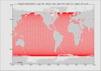
Jason-2 on its interleaved orbit after October 2016 (yellow) that was the same for Topex/Poseidon (after Sept.2002) and Jason-1 (after Feb.2009). The red ground tracks correspond to the Jason-2 nominal orbit (from 2008-Oct.2016) that is used by Jason-3 today. Download Google Earth files with Jason-3, Jason-2, Jason-1 and Topex/Poseidon ground tracks on nominal or interleaved orbits. Pass locatorReferenced orbit Jason-2 (2008-oct.2016) ,interlaced orbit, Jason-2 (after oct. 2016) |
Orbit parameters
| Main characteristics | ||
|---|---|---|
| Semi-major axis | 7 714.4278 km | |
| Eccentricity | 0.000095 | |
| Inclination (non-sun-synchronous) | 66.039° | |
| Auxiliary data | ||
| Reference altitude (equatorial) | 1336 km (1309.5 km from July 2017) | |
| Nodal period | 6 745.72 seconds (112'42" or 1h52') | |
| Repeat cycle | 9.9151 days | |
| Number of passes per cycle | 254 | |
| Ground track separation at Equator | 315 km | |
| Acute angle at Equator crossings | 39.5° | |
| Longitude at Equator of pass 1 | 99.9242° | |
| Orbital velocity | 7.2 km/s | |
| Ground scanning velocity | 5.8 km/s |
See Jason-2 ground tracks on Google Earth