


Latest News
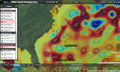
01.09.2020 Hurricane Laura seen by Altimeters
The altimeters have measured high values of Significant Wave Height and Wind Speed when flying over Laura Hurricane on August 25 and 26.
31.07.2020 August 2020: Tides off the Amazon River mouth
Altimetry brought a better knowledge of tides all around the world. Even now, they are used in various contexts, including to better understand some general ocean circulation phenomena.
27.05.2020 Survey on visualization tools
OceanDataLab launches a survey to improve its visualization tools.[more]
05.05.2020 OSTST CNES/EUMETSAT Joint Research Announcement 2020
CNES/EUMETSAT Joint Research Announcement (JRA) for the renewal of the Ocean Surface Topography Science Team[more]
04.05.2020 May 2020: Lake Chad might be recovering
Altimetry-derived water levels over lake Chad show a general stability of its two basins for the past 20 years, after the dramatic decrease of the 70s & 80s
30.04.2020 Release of CFOSAT SWIM L2P SWH 1Hz Nadir product

A new Wave product from SWIM/CFOSAT instrument, along-track and of level 2 plus (L2P) is available on AVISO+. [more]
28.04.2020 GPD+ Wet tropospheric correction disseminated by AVISO+

The GPD+ wet tropospheric correction, provided by the University of Porto, and present in the CTOH catalogue is now disseminated by AVISO+ with a temporal extension of Cryosat-2/Jason-2/Jason-3/Saral missions.[more]
News
 Archives .
- Aviso Newsletter .
- Search.
- Front-page news.
- Image of the month .
- Operational news and status .