Lake Chad might be recovering
Image of the Month - May 2020
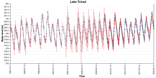
Lake Chad altimetry-derived water heights from Hydroweb (http://hydroweb.theia-land.fr) (credit Cnes/Legos)
Lake Chad, in the Sahelian zone of west-central Africa shrunk dramatically in the 1970s and 80s. Its area decreased by more than 90% and the lake split in two basins (North and South), with the northern basin being regularly dried up. With a local population largely dependent on agriculture and fishery, and an unstable political situation, this exacerbated the vulnerability of the region.
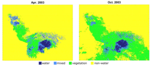
Since the 1990s, more favorable rainfall have been observed in western Sahel. Water extents estimated using optical imagery from 2001 to 2018 show that the southern pool area is quite stable, even slightly increasing. In the meantime the northern pool still decreases but at a slow pace, with higher interannual variability in the dry season, and the presence of water every year now. Altimetry-derived water levels over the whole lake also confirm the same stability and slight increase. Moreover, a comparison with total water storage derived from Grace monthly gravity fields indicates that a large part of Lake Chad water is stored in subsurface (soil moisture and groundwater) where a aquifer is present at a depth of ~70 m.
It thus seems that Lake Chad is not disappearing for now. The stored groundwater is acting as a precious buffer of rainfall variability, thus saving the lake for the near future at least.
Classical radar altimetry has been used to monitor large bodies of water as early as 1995, and is also used for rivers. The upcoming Swot mission will enable to monitor lake levels and extents globally at least once every 21 days (on average twice), with an enhanced capability to monitor smaller water bodies as well.
See also:
- Applications / hydrology: lakes and enclosed seas
- Applications: High-resolution hydrology
- Missions: Swot
Other websites on this topic:
- Hydroweb on Theia web site
Reference
- Pham-Duc, B., Sylvestre, F., Papa, F. et al. The Lake Chad hydrology under current climate change. Sci Rep 10, 5498 (2020). https://doi.org/10.1038/s41598-020-62417-w


