


Swot before Swot
Image of the Month - September 2020
When a satellite is the first of its kind, you can either wait to see what you'll get from it, with the risk of taking a large part of its lifetime to develop the necessary tools and algorithms, or use data as close as possible to what you'll have and be ready for the data as soon as you'll have them. Even after data are made available, comparing them with similar information can help in improving them or better understanding them.
The latter method has been the motto for Swot since the mission was decided, and a number of the Project and Science Team activities are focused on that. Such "proxy" data can come from actual data measured using other techniques, e.g. in situ or test instrument (such as AirSwot), from hydrographic model, or from computer simulations of the instrument.
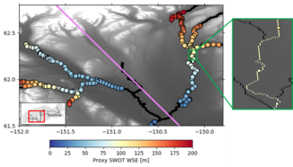
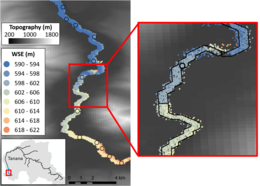
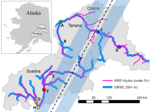
Proxy Swot observations of water surface elevation were generated for the Tanana River (Alaska, USA) during June 2015 (a low-flow case) following a five-year spin-up period and for the Susitna River (Alaska) during September 2012 (a high-flow case) using a high-resolution hydrologic routing and streamflow modeling framework which couples column land surface, terrain routing, and channel routing models. As a result, the hydrologic model captures all major water processes, including snowmelt, evaporation, soil moisture changes, surface runoff, groundwater storage, and streamflow. One method, ideal for river hydrology applications needing a general representation of Swot measurement, is to add random measurement error to model output to mimic SWOT error. A second method used model output as input to the CNES simulator to simulate Swot data, which is better suited for studies that require a comprehensive error budget.
When Swot will be launched (planned in Feb. 2022), the data will thus be used very quickly, first in the validation phase, but soon after in applications, pratical and scientific alike.
See also:
- Applications: High-resolution hydrology
- Missions: Swot
Reference
- Elmer, N. J., Hain, C., Hossain, F., Desroches, D., & Pottier, C., 2020: Generating proxy SWOT water surface elevations using WRF‐Hydro and the CNES SWOT Hydrology Simulator. Water Resources Research, 56, e2020WR027464. https://doi.org/10.1029/2020WR027464.
News
 Archives .
- Aviso Newsletter .
- Search.
- Front-page news.
- Image of the month .
- 2026 .
- 2025 .
- 2024 .
- 2023 .
- 2022 .
- 2021 .
- 2020 .
- Dec. 2020: Dispersion in the Mediterranean Sea.
- Nov. 2020: Altimeters see Pantanal waters at their lowest.
- Oct. 2020: Assessing storm impacts on the Mediterranean coasts.
- Sep. 2020: Swot before Swot.
- Aug. 2020: Tides off the Amazon River mouth.
- May 2020: Lake Chad might be recovering.
- Apr. 2020: Arcachon Bay between tides.
- Mar. 2020: CFOSat.
- Feb. 2020: Monitoring the small wobbles of our Earth's center of mass.
- Jan. 2020: Heat is going up in the Kerguelen fronts, following elephant seals.
- 2019 .
- 2018 .
- 2017 .
- 2016 .
- 2015 .
- 2014 .
- 2013 .
- 2012 .
- 2011 .
- 2010 .
- 2009 .
- 2008 .
- 2007 .
- 2006 .
- 2005 .
- 2004 .
- 2003 .
- 2002 .
- 2001 .
- 2000 .
- 1999 .
- 1998 .
- Operational news and status .