


Altimeters see Pantanal waters at their lowest
Image of the Month - November 2020
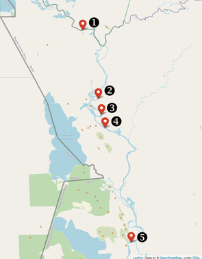
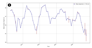
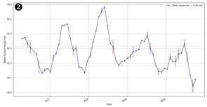
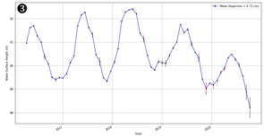
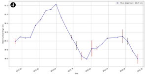
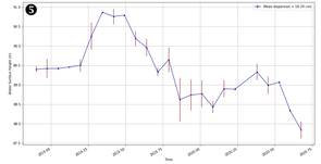
Virtual stations from altimeters over the Paraguai in the Pantanal area, from upstream to downstream, from left to right and top to bottom (first and last are out of the Pantanal proper). (Credit Hydroweb)
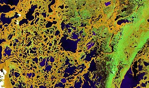
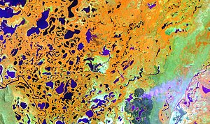
As mentioned last year in these pages, the Pantanal area is the largest tropical wetlands on Earth. This year, it might not be as true as usual, due to the very severe drought affecting the region. Precipitation during the wet season (Jan-May) was about half the usual. The lack of water holes and ponds helps fires to spread widely, burning an important part of the area (some estimates that more than 10 % are charred as of Sept. 6, 2020 (24,000 km²), other estimates are up to 25%). Biodiversity – plants and animals both – suffered from the drought and the fires, in particular the important jaguar population of the area.
Satellites help to assess such events over large areas, measuring the water levels with altimeters, assessing the land cover, fires spread, water extent or land use with optical satellites such as Sentinel-2. The comparison of the Sentinel-2 images highlights the great modifications such as the important redraw of water bodies, traducing an important drying of this sensitive ecosystem. Lots of burnt areas are also observable on the neighborhood of the wetlands but also within its core. Other satellites enable to measure soil moisture (SMOS). It is also a source of data which are available rapidly to scientists in countries downstream of a specific problem. In the near future Swot (launch is planned on February 2022) will provide with an even larger view of the water levels under its swath, also with the water extent.
See also:
- Applications / hydrology: Wetlands
- Applications: High-resolution hydrology
- Image of the Month, Apr. 2019: Pantanal wetlands
- Image of the Month, Mar. 2017: Satellites see the highs and lows of the biggest lake in China
- Missions: Swot
Other websites on this topic:
- Hydroweb on Theia web site
- Copernicus Land / global service
News
 Archives .
- Aviso Newsletter .
- Search.
- Front-page news.
- Image of the month .
- 2026 .
- 2025 .
- 2024 .
- 2023 .
- 2022 .
- 2021 .
- 2020 .
- Dec. 2020: Dispersion in the Mediterranean Sea.
- Nov. 2020: Altimeters see Pantanal waters at their lowest.
- Oct. 2020: Assessing storm impacts on the Mediterranean coasts.
- Sep. 2020: Swot before Swot.
- Aug. 2020: Tides off the Amazon River mouth.
- May 2020: Lake Chad might be recovering.
- Apr. 2020: Arcachon Bay between tides.
- Mar. 2020: CFOSat.
- Feb. 2020: Monitoring the small wobbles of our Earth's center of mass.
- Jan. 2020: Heat is going up in the Kerguelen fronts, following elephant seals.
- 2019 .
- 2018 .
- 2017 .
- 2016 .
- 2015 .
- 2014 .
- 2013 .
- 2012 .
- 2011 .
- 2010 .
- 2009 .
- 2008 .
- 2007 .
- 2006 .
- 2005 .
- 2004 .
- 2003 .
- 2002 .
- 2001 .
- 2000 .
- 1999 .
- 1998 .
- Operational news and status .